IMAGES TAKEN NEAR TO
West Knighton, DORCHESTER, DT2 8PF
Introduction
This page details the photographs taken nearby to DT2 8PF by members of the Geograph project.
The Geograph project started in 2005 with the aim of publishing, organising and preserving representative images for every square kilometre of Great Britain, Ireland and the Isle of Man.

There are currently over 7.5m images from over14,400 individuals and you can help contribute to the project by visiting https://www.geograph.org.uk
Image Map (Loading...)


Getting Data...Please wait
Leaflet Map data © OpenStreetMap
Images are licensed for reuse under creativecommons.org/licenses/by-sa/2.0
Notes
- Clicking on the map will re-center to the selected point.
- The higher the marker number, the further away the image location is from the centre of the postcode.
Image Listing (75 Images Found)
Images are licensed for reuse under creativecommons.org/licenses/by-sa/2.0
Image
Details
Distance
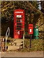
1
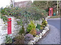
West Knighton: phone box and redundant postbox
Because (a) the postbox is still red, and (b) I did not notice a replacement nearby, my guess is that this Victorian postbox has only recently been taken out of service. However, I had not travelled right through the village so I may have missed the replacement.
Image: © Chris Downer
Taken: 27 Dec 2008
0.01 miles
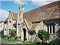
2
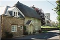
West Knighton: Church Cottage
A smart thatch, with the Image in the distance.
Image: © Chris Downer
Taken: Unknown
0.01 miles
3
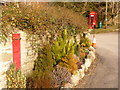
West Knighton: postboxes old and new
This view ironically both proves and disproves my comments in the description of this photo: Image
On the one hand, we can now see the replacement postbox, by the phone box in the background – so I was right on that count. But the old one is still red, so I was wrong on that count.
Image: © Chris Downer
Taken: 13 Feb 2010
0.01 miles
4
![West Knighton village [4]](https://s0.geograph.org.uk/geophotos/07/26/23/7262368_67e165f6_120x120.jpg)
West Knighton village [4]
Church Cottage, Highgate Lane, was built in the early 18th century with 20th century alterations and extension. Constructed of rubble stone with dressed quoins under a thatch roof. Listed, grade II, with details at: https://historicengland.org.uk/listing/the-list/list-entry/1119209
West Knighton is a village in Dorset, some 3 miles (4.8 km) southeast of Dorchester. There is evidence of settlement from the Stone Age onwards. An agricultural village until the mid 20th century, most working residents now commute to Dorchester.
Image: © Michael Dibb
Taken: 3 Jun 2022
0.02 miles
5
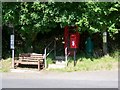
Telephone box, West Knighton
The K6 type telephone box hides under the tree with a modern postbox in front of it.
Image: © Maigheach-gheal
Taken: 15 Jun 2009
0.02 miles
6
West Knighton: postbox № DT2 23 and phone
The postbox is a recent replacement for a Victorian one set into a nearby wall – see Image
Image: © Chris Downer
Taken: 13 Feb 2010
0.03 miles
7
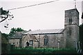
West Knighton: parish church of St. Peter
West Knighton is a parish in its own right, unlike East Knighton, a couple of miles along the A352.
Image: © Chris Downer
Taken: Unknown
0.03 miles
9
![West Knighton village [6]](https://s1.geograph.org.uk/geophotos/07/26/23/7262377_5d3f4220_120x120.jpg)
West Knighton village [6]
These four attached cottages are named Smithy, Middle, Angel and Steps. Built in the mid 18th century, with some 20th century refenestration. Constructed of rubble stone, rendered and colour washed under a thatch roof. Listed, grade II, with details at: https://historicengland.org.uk/listing/the-list/list-entry/1154053
West Knighton is a village in Dorset, some 3 miles (4.8 km) southeast of Dorchester. There is evidence of settlement from the Stone Age onwards. An agricultural village until the mid 20th century, most working residents now commute to Dorchester.
Image: © Michael Dibb
Taken: 3 Jun 2022
0.03 miles
10
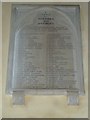
St Peter, West Knighton: Table of Kindred and Affinity
Image: © Basher Eyre
Taken: 3 Sep 2012
0.03 miles