IMAGES TAKEN NEAR TO
Ringstead, DORCHESTER, DT2 8NQ
Introduction
This page details the photographs taken nearby to DT2 8NQ by members of the Geograph project.
The Geograph project started in 2005 with the aim of publishing, organising and preserving representative images for every square kilometre of Great Britain, Ireland and the Isle of Man.

There are currently over 7.5m images from over14,400 individuals and you can help contribute to the project by visiting https://www.geograph.org.uk
Image Map
Images are licensed for reuse under creativecommons.org/licenses/by-sa/2.0
Notes
- Clicking on the map will re-center to the selected point.
- The higher the marker number, the further away the image location is from the centre of the postcode.
Image Listing (20 Images Found)
Images are licensed for reuse under creativecommons.org/licenses/by-sa/2.0
Image
Details
Distance
2
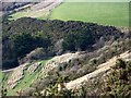
Strip lynchets, Ringstead
Lynchets are man-made step or terrace on a hill slope, carved out to make land fit for cultivation by the plough. Some lynchets were deliberately created with stone facing on the 'riser' of the step supporting the level 'tread' above. Such lynchets often occur as a flight ascending a slope, creating a series of strip lynchets.
Historians generally agree that most lynchets were made between early Anglo Saxon times and the 16th century. The ones here are thought to be Early Medieval.
Image: © Maigheach-gheal
Taken: 28 Dec 2009
0.05 miles
4
Strip lynchets, Ringstead
Lynchets are man-made step or terrace on a hill slope, carved out to make land fit for cultivation by the plough. Some lynchets were deliberately created with stone facing on the 'riser' of the step supporting the level 'tread' above. Such lynchets often occur as a flight ascending a slope, creating a series of strip lynchets.
Historians generally agree that most lynchets were made between early Anglo Saxon times and the 16th century. The ones here are thought to be Early Medieval.
Image: © Maigheach-gheal
Taken: 28 Dec 2009
0.07 miles
5
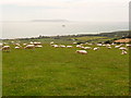
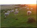
Ringstead: sheep on South Down
These grazers probably do not appreciate the magnificent views across to the Isle of Portland as much as do the many people who were up here at the National Trust car park today.
Image: © Chris Downer
Taken: 25 Jul 2009
0.11 miles
6
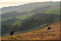
Romantic photoshoot above Ringstead Bay, Dorset
Image: © Edmund Shaw
Taken: 8 Sep 2014
0.12 miles
7
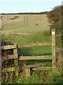
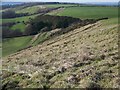
Stile on South Down, Ringstead
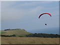
A footpath enters a large steep field on the side of a chalk hill above Ringstead. The National Trust car park is at the top of the hill. The two figures are climbing back up to make another descent on their land-boards. The hill is also used as a launching point for para-gliders.
Image: © Jim Champion
Taken: 24 Oct 2006
0.12 miles
8
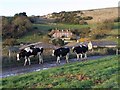
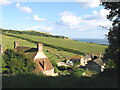
Cows near South Down Farm, Ringstead
These cows were cautiously walking along the road from the farm to the fields, probably returning from milking. Behind them is South Down Farm and the steep chalk hillside of South Down.
Image: © Jim Champion
Taken: 24 Oct 2006
0.12 miles
10
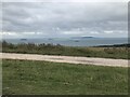
South Down
This elevated ground about a kilometre inland has fine coastal views. At the top of the pasture is an area for car parking.
Image: © Andrew Smith
Taken: 8 Jun 2008
0.13 miles