IMAGES TAKEN NEAR TO
Whitcombe, DORCHESTER, DT2 8NL
Introduction
This page details the photographs taken nearby to DT2 8NL by members of the Geograph project.
The Geograph project started in 2005 with the aim of publishing, organising and preserving representative images for every square kilometre of Great Britain, Ireland and the Isle of Man.

There are currently over 7.5m images from over14,400 individuals and you can help contribute to the project by visiting https://www.geograph.org.uk
Image Map
Images are licensed for reuse under creativecommons.org/licenses/by-sa/2.0
Notes
- Clicking on the map will re-center to the selected point.
- The higher the marker number, the further away the image location is from the centre of the postcode.
Image Listing (5 Images Found)
Images are licensed for reuse under creativecommons.org/licenses/by-sa/2.0
Image
Details
Distance
1
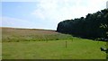
Woods and fields at Whitcombe Barn
Looking west up the slope along the side of the woods that lies on the north west side of Whitcombe barn
Image: © Nigel Mykura
Taken: 1 Jul 2008
0.06 miles
2
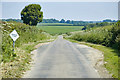
Whitcombe Road
Road from Came Down and Weymouth down towards Whitcombe.
Image: © Paul Snelling
Taken: 17 Jun 2006
0.10 miles
3
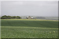
Whitcombe Barn and Whitcombe Barn Farm
The Barn is on the left and the Farmhouse just right of centre
Image: © Stuart Cankett
Taken: 12 May 2007
0.11 miles
4
Whitcombe Barn Farm
Not marked on OS 1:50000
Image: © Stuart Cankett
Taken: 12 May 2007
0.14 miles
5
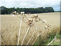
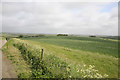
Dead Umbellifer near Whitcombe Barn
Whitcombe Barn Plantation lies in the background. Just visible in front of this copse is the white tape running alongside the Whitcombe Racing Stables gallop.
Image: © Ivan Hall
Taken: 12 Aug 2009
0.17 miles