IMAGES TAKEN NEAR TO
Warmwell Road, DT2 8GR
Introduction
This page details the photographs taken nearby to Warmwell Road, DT2 8GR by members of the Geograph project.
The Geograph project started in 2005 with the aim of publishing, organising and preserving representative images for every square kilometre of Great Britain, Ireland and the Isle of Man.

There are currently over 7.5m images from over14,400 individuals and you can help contribute to the project by visiting https://www.geograph.org.uk
Image Map (Loading...)


Getting Data...Please wait
Leaflet Map data © OpenStreetMap
Images are licensed for reuse under creativecommons.org/licenses/by-sa/2.0
Notes
- Clicking on the map will re-center to the selected point.
- The higher the marker number, the further away the image location is from the centre of the postcode.
Image Listing (170 Images Found)
Images are licensed for reuse under creativecommons.org/licenses/by-sa/2.0
Image
Details
Distance
1
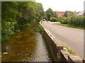
Puddletown: The Backwater
The name not of the River Piddle, but of the road running alongside it.
Image: © Chris Downer
Taken: 7 Jun 2009
0.04 miles
2
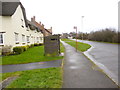
Puddletown, bus shelter
On Blandford Road. Housing to the left is part of a recent development.
Image: © Mike Faherty
Taken: 15 Mar 2013
0.05 miles
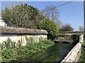
5
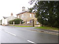
Puddletown House
On High Street; offering art courses. http://www.artresqdorset.com/
Image: © Mike Faherty
Taken: 15 Mar 2013
0.10 miles
6
![Puddletown houses [8]](https://s2.geograph.org.uk/geophotos/06/77/26/6772642_af1bde2b_120x120.jpg)
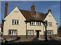
Puddletown houses [8]
Puddletown House, number 6 High Street is a substantial early 19th century house.
The village of Puddletown, earlier known as Piddletown is located alongside the River Piddle some 4½ miles north east of Dorchester and is now essentially a commuter village. There is evidence of occupation from prehistoric times in the form of some 30 round barrows. The use of watermeadows in Dorset was first developed in Puddletown in the 17th century. The village was the inspiration for the fictional settlement of Weatherbury in the novel Far from the Madding Crowd by Thomas Hardy.
Image: © Michael Dibb
Taken: 11 Dec 2020
0.10 miles
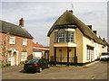
7
Puddletown: former Prince of Wales Inn
This former pub has been converted into flats but retains the name Prince of Wales.
Image: © Chris Downer
Taken: 27 Sep 2008
0.10 miles
8
![Puddletown houses [12]](https://s3.geograph.org.uk/geophotos/06/77/26/6772647_2725fb05_120x120.jpg)
Puddletown houses [12]
Tudor Cottage 14 Mill Street is dated 1573. Constructed with walls of stone and flint bands with a thatched roof. There is a 20th century extension at the rear. Listed, grade II, with details at: https://historicengland.org.uk/listing/the-list/list-entry/1303778
The village of Puddletown, earlier known as Piddletown is located alongside the River Piddle some 4½ miles north east of Dorchester and is now essentially a commuter village. There is evidence of occupation from prehistoric times in the form of some 30 round barrows. The use of watermeadows in Dorset was first developed in Puddletown in the 17th century. The village was the inspiration for the fictional settlement of Weatherbury in the novel Far from the Madding Crowd by Thomas Hardy.
Image: © Michael Dibb
Taken: 11 Dec 2020
0.10 miles
9
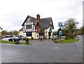
Puddletown, The Blue Vinny
Brewer's Tudor style pub on Blandford Road. Back bar left, eating and drinking front and right; large garden with playground. Cask ales on offer at my visit: McMullen AK, Sharp's Doom Bar, Young's Bitter. For some customer comments, see http://www.beerintheevening.com/pubs/s/27/2774/Blue_Vinny/Puddletown
Image: © Mike Faherty
Taken: 15 Mar 2013
0.11 miles
10
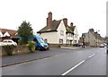
Puddletown, Prince of Wales Apartments
Converted public house on High Street.
Image: © Mike Faherty
Taken: 15 Mar 2013
0.11 miles