IMAGES TAKEN NEAR TO
Woodlands, DORCHESTER, DT2 8EH
Introduction
This page details the photographs taken nearby to Woodlands, DT2 8EH by members of the Geograph project.
The Geograph project started in 2005 with the aim of publishing, organising and preserving representative images for every square kilometre of Great Britain, Ireland and the Isle of Man.

There are currently over 7.5m images from over14,400 individuals and you can help contribute to the project by visiting https://www.geograph.org.uk
Image Map (107 Images)


Getting Data...Please wait
Leaflet Map data © OpenStreetMap
Images are licensed for reuse under creativecommons.org/licenses/by-sa/2.0
Notes
- Clicking on the map will re-center to the selected point.
- The higher the marker number, the further away the image location is from the centre of the postcode.
Image Listing (107 Images Found)
Images are licensed for reuse under creativecommons.org/licenses/by-sa/2.0
Image
Details
Distance
1
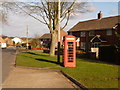
Broadmayne: phone box in Chalky Road
A traditional red telephone box on the road heading south out of the village.
Image: © Chris Downer
Taken: 13 Feb 2010
0.03 miles
2
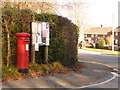
Broadmayne: postbox № DT2 158, Rectory Road
This Elizabeth II-reign pillar box is emptied each morning, except Sunday, at 11 o'clock. The Image can be seen in the background.
Image: © Chris Downer
Taken: 13 Feb 2010
0.05 miles

4
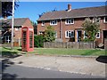
Telephone box, Broadmayne
A K6 type telephone box in the village.
Image: © Maigheach-gheal
Taken: 15 Jun 2009
0.06 miles
5
![Broadmayne features [3]](https://s2.geograph.org.uk/geophotos/07/26/14/7261438_461ac404_120x120.jpg)
Broadmayne features [3]
At the junction of Chalky Road and Cowleaze Road stands this memorial to the men of the U S Army who passed through Broadmayne on their way to the landings in Normandy. See also Image
Broadmayne is a village in Dorset, some 3 miles southeast of Dorchester. The village is astride the A352 road from Dorchester to Wareham. There is evidence of settlement from the Stone Age onwards. In addition to agricultural activities, there was a brickworks to the north of the village. At the approach of D-Day in 1944, the area around the village was covered with Nissen huts and tents as assembly area D5 for the invasion.
Image: © Michael Dibb
Taken: 2 Jun 2022
0.08 miles
6
![Broadmayne features [4]](https://s3.geograph.org.uk/geophotos/07/26/14/7261439_d6e79740_120x120.jpg)
Broadmayne features [4]
At the junction of Chalky Road and Cowleaze Road stands a memorial to the men of the U S Army who passed through Broadmayne on their way to the landings in Normandy. See also Image
Broadmayne is a village in Dorset, some 3 miles southeast of Dorchester. The village is astride the A352 road from Dorchester to Wareham. There is evidence of settlement from the Stone Age onwards. In addition to agricultural activities, there was a brickworks to the north of the village. At the approach of D-Day in 1944, the area around the village was covered with Nissen huts and tents as assembly area D5 for the invasion.
Image: © Michael Dibb
Taken: 2 Jun 2022
0.08 miles
7
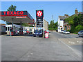
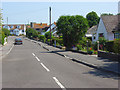
Main Street, Broadmayne
The A352 passes the petrol station at the foot of Chalky Road.
Image: © Andrew Smith
Taken: 8 Jun 2008
0.10 miles
8
Rectory Close, Broadmayne
A more modern area near the southwestern edge of the village. The church's tower can just be seen.
Image: © Andrew Smith
Taken: 8 Jun 2008
0.11 miles
9
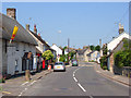
Main Street, Broadmayne
The A352 passes some of the village's attractive cottages. At the junction with Osmington Drove.
Image: © Andrew Smith
Taken: 8 Jun 2008
0.12 miles
10
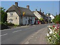
Main Street, Broadmayne
The A352 passes the post office and shop (in the small extension). Roses and valerian spill out of a garden.
Image: © Andrew Smith
Taken: 8 Jun 2008
0.12 miles