IMAGES TAKEN NEAR TO
Bramble Drove, DORCHESTER, DT2 8ED
Introduction
This page details the photographs taken nearby to Bramble Drove, DT2 8ED by members of the Geograph project.
The Geograph project started in 2005 with the aim of publishing, organising and preserving representative images for every square kilometre of Great Britain, Ireland and the Isle of Man.

There are currently over 7.5m images from over14,400 individuals and you can help contribute to the project by visiting https://www.geograph.org.uk
Image Map
Images are licensed for reuse under creativecommons.org/licenses/by-sa/2.0
Notes
- Clicking on the map will re-center to the selected point.
- The higher the marker number, the further away the image location is from the centre of the postcode.
Image Listing (63 Images Found)
Images are licensed for reuse under creativecommons.org/licenses/by-sa/2.0
Image
Details
Distance
1
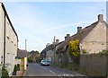
Broadmayne
Cottages on the A352, the main road through the village. Looking east at the west end of the village.
Image: © Nigel Mykura
Taken: 22 Jul 2008
0.16 miles
2
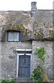
Old Cottage Broadmayne
Old thatched cottage on the main street through the village.
Image: © Nigel Mykura
Taken: 22 Jul 2008
0.18 miles
3
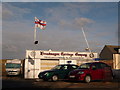
Broadmayne: Broadmayne Carriage Company
I think this is the farthest inland that I have seen the RNLI flag flying!
Image: © Chris Downer
Taken: 13 Feb 2010
0.18 miles
4
![Broadmayne features [6]](https://s0.geograph.org.uk/geophotos/07/26/23/7262328_284b7791_120x120.jpg)
Broadmayne features [6]
This fine doorway reveals the former presence of a house.
Broadmayne is a village in Dorset, some 3 miles southeast of Dorchester. The village is astride the A352 road from Dorchester to Wareham. There is evidence of settlement from the Stone Age onwards. In addition to agricultural activities, there was a brickworks to the north of the village. At the approach of D-Day in 1944, the area around the village was covered with Nissen huts and tents as assembly area D5 for the invasion.
Image: © Michael Dibb
Taken: 2 Jun 2022
0.18 miles
5
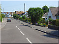
Rectory Close, Broadmayne
A more modern area near the southwestern edge of the village. The church's tower can just be seen.
Image: © Andrew Smith
Taken: 8 Jun 2008
0.18 miles
6
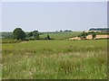
Farmland, Broadmayne
A view across fields from the A352 immediately west of the village.
Image: © Andrew Smith
Taken: 8 Jun 2008
0.19 miles
7
![Broadmayne houses [5]](https://s0.geograph.org.uk/geophotos/07/26/14/7261472_ebb13064_120x120.jpg)
Broadmayne houses [5]
Lindean, number 10 Main Street, a former farmhouse was built in the late 16th century, and enlarged in the 17th century. Constructed of rubble stone under a thatch roof. There is a projecting staircase embrasure on the front wall. Some original internal features and fittings remain. Listed, grade II, with details at: https://historicengland.org.uk/listing/the-list/list-entry/1119261
Broadmayne is a village in Dorset, some 3 miles southeast of Dorchester. The village is astride the A352 road from Dorchester to Wareham. There is evidence of settlement from the Stone Age onwards. In addition to agricultural activities, there was a brickworks to the north of the village. At the approach of D-Day in 1944, the area around the village was covered with Nissen huts and tents as assembly area D5 for the invasion.
Image: © Michael Dibb
Taken: 2 Jun 2022
0.20 miles
8
![Broadmayne houses [6]](https://s1.geograph.org.uk/geophotos/07/26/23/7262329_70453c60_120x120.jpg)
Broadmayne houses [6]
Cob Barn, 3A Main Street, is a dwelling converted from a barn. Constructed of plastered cob on a high rubble stone base under a slate roof.
Broadmayne is a village in Dorset, some 3 miles southeast of Dorchester. The village is astride the A352 road from Dorchester to Wareham. There is evidence of settlement from the Stone Age onwards. In addition to agricultural activities, there was a brickworks to the north of the village. At the approach of D-Day in 1944, the area around the village was covered with Nissen huts and tents as assembly area D5 for the invasion.
Image: © Michael Dibb
Taken: 2 Jun 2022
0.20 miles
9
![Broadmayne houses [7]](https://s0.geograph.org.uk/geophotos/07/26/23/7262332_2c261364_120x120.jpg)
Broadmayne houses [7]
Manor Farmhouse, number 5 Main Street, was built in the 17th century and greatly altered in the 19th century. Constructed of plastered stone with some brick, the front is hung with mathematical tiles, all under a slate roof. Listed, grade II, with details at: https://historicengland.org.uk/listing/the-list/list-entry/1323942
Broadmayne is a village in Dorset, some 3 miles southeast of Dorchester. The village is astride the A352 road from Dorchester to Wareham. There is evidence of settlement from the Stone Age onwards. In addition to agricultural activities, there was a brickworks to the north of the village. At the approach of D-Day in 1944, the area around the village was covered with Nissen huts and tents as assembly area D5 for the invasion.
Image: © Michael Dibb
Taken: 2 Jun 2022
0.20 miles
10
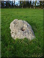
Stone from the Littlemayne Stone Circle
A different view of one of the remaining stones of the Littlemayne Stone Circle.
Over the years a number of the stones have been moved to the side of the fields to allow for cultivations.
Image: © Rob Barnish
Taken: 10 Nov 2007
0.20 miles