IMAGES TAKEN NEAR TO
Chaldon Herring, DORCHESTER, DT2 8DW
Introduction
This page details the photographs taken nearby to DT2 8DW by members of the Geograph project.
The Geograph project started in 2005 with the aim of publishing, organising and preserving representative images for every square kilometre of Great Britain, Ireland and the Isle of Man.

There are currently over 7.5m images from over14,400 individuals and you can help contribute to the project by visiting https://www.geograph.org.uk
Image Map
Images are licensed for reuse under creativecommons.org/licenses/by-sa/2.0
Notes
- Clicking on the map will re-center to the selected point.
- The higher the marker number, the further away the image location is from the centre of the postcode.
Image Listing (3 Images Found)
Images are licensed for reuse under creativecommons.org/licenses/by-sa/2.0
Image
Details
Distance
1
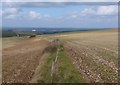
Chaldon Down
View north from the South West Coast Path just south of Chideock Farm
Image: © Nigel Mykura
Taken: 10 Oct 2009
0.04 miles
2
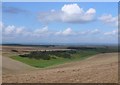
Dry Valley near Chideock Farm
This dry valley in the chalk is just west of Chideock farm and runs north from the clifftops near The Warren
Image: © Nigel Mykura
Taken: 10 Oct 2009
0.13 miles
3
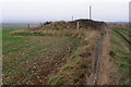
Wardstone Barrow
This bronze-age round barrow is on the chalk ridge just inland from the coast, between the White Nothe headland and West Lulworth. It was originally one of a pair, but the eastern barrow has been levelled by farming activity. The mound is 15 metres in diameter, up to 2 metres high, and the surrounding ditch is mostly infilled. The mound is now overgrown with gorse and brambles.
The name of this barrow probably comes from the Anglo-Saxon "weard-stān", meaning stone where watch was kept. The barrow is located in a very prominent position on the coastal ridge with good visibility all around, over land and sea. There is no record of a megalith at the site - only of an excavation in 1867 that uncovered a cinerary urn.
The track on the right of the photograph is a permissive footpath, leading to Chideock Farm some 300 metres further on. The research reactor buildings on Winfrith Heath can be seen in the misty distance, just to the right of the barrow mound.
Image: © Jim Champion
Taken: 24 Dec 2007
0.20 miles