IMAGES TAKEN NEAR TO
Higher Woodsford, DORCHESTER, DT2 8BL
Introduction
This page details the photographs taken nearby to DT2 8BL by members of the Geograph project.
The Geograph project started in 2005 with the aim of publishing, organising and preserving representative images for every square kilometre of Great Britain, Ireland and the Isle of Man.

There are currently over 7.5m images from over14,400 individuals and you can help contribute to the project by visiting https://www.geograph.org.uk
Image Map
Images are licensed for reuse under creativecommons.org/licenses/by-sa/2.0
Notes
- Clicking on the map will re-center to the selected point.
- The higher the marker number, the further away the image location is from the centre of the postcode.
Image Listing (5 Images Found)
Images are licensed for reuse under creativecommons.org/licenses/by-sa/2.0
Image
Details
Distance
1
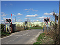
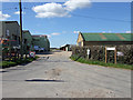
Level Crossing at Higher Woodsford
Looking northwest in the direction of Woodsford. The sheds beyond belong to the Dairy Centre at Higher Woodsford.
Image: © Mike Searle
Taken: 21 Mar 2007
0.04 miles
2
Level Crossing
This is looking north across the crossing at Higher Woodsford
Image: © Nigel Mykura
Taken: 11 May 2008
0.05 miles
3
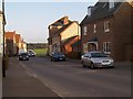
The Dairy Centre at Higher Woodsford
Despite the name, there doesn't appear to be a dairy herd on site, so presumably this is a distribution centre of some description.
Image: © Mike Searle
Taken: 21 Mar 2007
0.07 miles