IMAGES TAKEN NEAR TO
Old Sherborne Road, DORCHESTER, DT2 7TR
Introduction
This page details the photographs taken nearby to Old Sherborne Road, DT2 7TR by members of the Geograph project.
The Geograph project started in 2005 with the aim of publishing, organising and preserving representative images for every square kilometre of Great Britain, Ireland and the Isle of Man.

There are currently over 7.5m images from over14,400 individuals and you can help contribute to the project by visiting https://www.geograph.org.uk
Image Map
Images are licensed for reuse under creativecommons.org/licenses/by-sa/2.0
Notes
- Clicking on the map will re-center to the selected point.
- The higher the marker number, the further away the image location is from the centre of the postcode.
Image Listing (21 Images Found)
Images are licensed for reuse under creativecommons.org/licenses/by-sa/2.0
Image
Details
Distance
1
Giant's Head Farm
The Wessex Ridgeway crosses the road above Yelcombe Bottom at this point, passing a fogbound Giant's Head Farm
Image: © Chris Heaton
Taken: 5 Feb 2019
0.01 miles
2
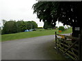
Minterne Parva, camp site
Giants Head Caravan & Camping Park. http://www.giantshead.co.uk/
Image: © Mike Faherty
Taken: 1 May 2011
0.01 miles
3
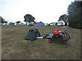
Giant's Head campsite
A rather good campsite rewards another climb. I could see all the way back to Win Green, a hill crossed at the start of the day.
Like the previous evening the skyline was dominated by bright lights on the edge of Shaftsbury.
Image: © Richard Webb
Taken: 2 Sep 2022
0.03 miles
4
Gales Hill approaching Giant's Head Farm
Image: © John Firth
Taken: 12 Apr 2013
0.10 miles
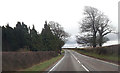
5
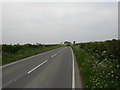
Minterne Parva, Old Sherborne Road
The earlier route from Dorchester to Sherborne, meeting the roughly parallel A352 at Middlemarsh; often less busy than its neighbour, and enjoying good views down into the neighbouring valleys.
Image: © Mike Faherty
Taken: 1 May 2011
0.11 miles
6
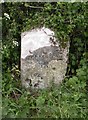
Old Milestone by the UC road, north east of Cerne Abbas
Stone post (plate lost) by the UC road, in parish of CERNE ABBAS (WEST DORSET District), near Giants Head Campsite, about 150m south, on a narrow verge/bank against the hedge, on West side of road. Dorset 1 (limestone), erected by the Weymouth, Melcombe Regis & Dorchester turnpike trust in the 19th century. Damaged.
Inscription reads:-
(8)
(DORCHES)TER
SHERBORNE
10
Grade II Listed. List Entry Number:1152750
https://historicengland.org.uk/listing/the-list/list-entry/1152750
Milestone Society National ID: DO_DOSB08.
Image: © Mike Faherty
Taken: 1 May 2007
0.13 miles
7
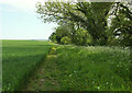
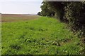
Footpath from Watts Hill
Footpath S13 2 heads along a plateau edge near Giant's Head Farm.
Image: © Derek Harper
Taken: 21 May 2022
0.14 miles
8
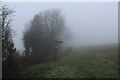
Fingerpost at Giant's Head
The Wessex Ridgeway at Giant's Head on a gloomy February morning.
Complete contrast to a previous photograph taken at the same place Image]
Image: © Chris Heaton
Taken: 5 Feb 2019
0.15 miles
9
Footpath to Cerne Abbas
Footpath S13 2, seen from close to the stile onto Gales Hill, follows the field boundary along which runs the parish boundary between Cerne Abbas (this side) and Minterne Magna.
Image: © Derek Harper
Taken: 28 Aug 2017
0.15 miles
10
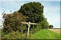
Signpost on the Wessex Ridgeway
The Wessex Ridgeway follows bridleway S13 6 (right)/ S31 8 (left) across footpath S13 2 (behind and ahead). The reason for change in numbering of the bridleway is the parish boundary it crosses, which runs along the field boundary the path is following, between Cerne Abbas (this side) and Minterne Magna.
Image: © Derek Harper
Taken: 28 Aug 2017
0.15 miles