IMAGES TAKEN NEAR TO
Alton Pancras, DORCHESTER, DT2 7RW
Introduction
This page details the photographs taken nearby to DT2 7RW by members of the Geograph project.
The Geograph project started in 2005 with the aim of publishing, organising and preserving representative images for every square kilometre of Great Britain, Ireland and the Isle of Man.

There are currently over 7.5m images from over14,400 individuals and you can help contribute to the project by visiting https://www.geograph.org.uk
Image Map
Images are licensed for reuse under creativecommons.org/licenses/by-sa/2.0
Notes
- Clicking on the map will re-center to the selected point.
- The higher the marker number, the further away the image location is from the centre of the postcode.
Image Listing (56 Images Found)
Images are licensed for reuse under creativecommons.org/licenses/by-sa/2.0
Image
Details
Distance
1
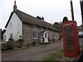
Alton Pancras: the old post office
This attractive cottage was the village post office until its closure in 1977. There had been a post office in the village since 1886, although it was named plain Alton until October 1908.
A reminder of the former function of the cottage survives in the form of a 'Ludlow' postbox towards the far end - see Image for a close-up.
Image: © Chris Downer
Taken: 28 Nov 2013
0.01 miles
2
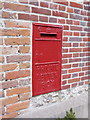
Alton Pancras: private postbox at the old post office
This old postbox is in the wall of Image and remains in use as a letterbox for the cottage's incoming mail. It is a 'Ludlow' box, a design named after its designer and intended specifically for use at sub-post offices, often incorporated within a window or, as here, wall. It would originally have had an enamel plate on the large central rectangle. See Image for a similar example still in use.
Image: © Chris Downer
Taken: 28 Nov 2013
0.01 miles
3
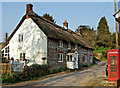
The Old Post Office at Alton Pancras
Grade II listed former cottage and shop, and post office. Dated 1826.
Image: © Mike Searle
Taken: 2 Apr 2007
0.02 miles
4
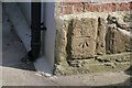
Benchmark on cottage, Alton Pancras
Ordnance Survey benchmark on cottage in Alton Pancras, described on database at http://www.bench-marks.org.uk/bm69121.
Image: © Becky Williamson
Taken: 13 Mar 2016
0.02 miles
5
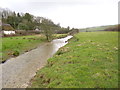
Alton Pancras, River Piddle
Looking downstream. The Piddle, a chalk stream, flows into Poole Harbour near Wareham.
Image: © Mike Faherty
Taken: 9 Mar 2013
0.08 miles
6
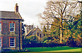
Alton Pancras, Church and Manor House, 1989
View westward.
Image: © Ben Brooksbank
Taken: 15 Jan 1989
0.09 miles
7
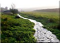
River Piddle, Alton Pancras
At this point near the top of the Piddle valley, the river is actually quite a small stream. The source of the river is said to be close to the village church. In this picture looking south the river is actually running along the northing grid line so that on the right of the river is ST6902 and on the left ST7002
Image: © Nigel Mykura
Taken: 30 Dec 2008
0.09 miles
8
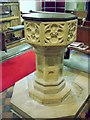
Font, St Pancras's Church
The font dates from the 15th century. Its cover reminds one of the days when fonts were held locked to prevent superstitious people stealing the holy water and at the edge of its lead lining there are still the remains of its old hinge and lock.
Image: © Maigheach-gheal
Taken: 28 Jul 2010
0.09 miles
9
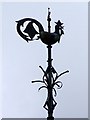
Weathercock, St Pancras's Church
It was a papal edict in the 9th century that was responsible for the proliferation of weathercocks on churches. This edict required every Church in Christendom to be mounted by a cockerel. This symbol was to recall Peter's betrayal of Christ (LUKE 22:34) "I tell thee, Peter, the cock shall not crow this day, before that thou shalt thrice deny that thou knowest me". Although only the symbol of the cockerel was required by the edict, the motif, it seems, was quickly wedded with the weathervane. By the 13th century the word for weathercock (gallum) and weathervane (ventrologium) had become interchangeable. Interestingly, early weathercocks did not include cardinal letters, as Christian churches always lay east to west.
Image: © Maigheach-gheal
Taken: 28 Jul 2010
0.09 miles