IMAGES TAKEN NEAR TO
Turnerspuddle, DORCHESTER, DT2 7JB
Introduction
This page details the photographs taken nearby to DT2 7JB by members of the Geograph project.
The Geograph project started in 2005 with the aim of publishing, organising and preserving representative images for every square kilometre of Great Britain, Ireland and the Isle of Man.

There are currently over 7.5m images from over14,400 individuals and you can help contribute to the project by visiting https://www.geograph.org.uk
Image Map (Loading...)


Getting Data...Please wait
Leaflet Map data © OpenStreetMap
Images are licensed for reuse under creativecommons.org/licenses/by-sa/2.0
Notes
- Clicking on the map will re-center to the selected point.
- The higher the marker number, the further away the image location is from the centre of the postcode.
Image Listing (4 Images Found)
Images are licensed for reuse under creativecommons.org/licenses/by-sa/2.0
Image
Details
Distance
1
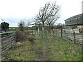
Gateways At Turners Puddle
We believe horses can go over the low barriers on the left, whereas pushchairs can go through the opening on the right. Both are designed to prevent access by motorcycles.
Image: © Lorraine and Keith Bowdler
Taken: 24 Feb 2012
0.18 miles
2
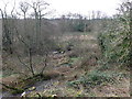
Piddle Valley Marshland
This low lying land along side the River Piddle just to the south east of Turners Puddle is very wet and boggy marshland with no practical use and it is consequently just left as waste scrub land.
Image: © Nigel Mykura
Taken: 1 Feb 2013
0.19 miles
3
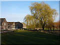
Willows and Farm Buildings, Turners Puddle
Image: © Ivan Hall
Taken: 13 Mar 2011
0.20 miles
