IMAGES TAKEN NEAR TO
Holywell, DORCHESTER, DT2 0LQ
Introduction
This page details the photographs taken nearby to DT2 0LQ by members of the Geograph project.
The Geograph project started in 2005 with the aim of publishing, organising and preserving representative images for every square kilometre of Great Britain, Ireland and the Isle of Man.

There are currently over 7.5m images from over14,400 individuals and you can help contribute to the project by visiting https://www.geograph.org.uk
Image Map (Loading...)


Getting Data...Please wait
Leaflet Map data © OpenStreetMap
Images are licensed for reuse under creativecommons.org/licenses/by-sa/2.0
Notes
- Clicking on the map will re-center to the selected point.
- The higher the marker number, the further away the image location is from the centre of the postcode.
Image Listing (18 Images Found)
Images are licensed for reuse under creativecommons.org/licenses/by-sa/2.0
Image
Details
Distance
1
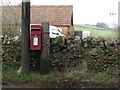
Holywell: postbox № DT2 129
This Elizabeth II-reign postbox stands opposite a row of cottages, the end one of which is called The Old Post House - this must therefore be the former post office which closed in 1966. The box is emptied daily except Sunday at 11am.
Image: © Chris Downer
Taken: 23 Jan 2011
0.00 miles
2

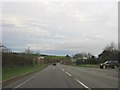
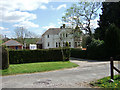
Holywell
The view is from the western approach road through the village, now effectively cut in two by the busy A37 Dorchester to Yeovil road.
Image: © Mike Searle
Taken: 18 Apr 2007
0.03 miles
5
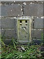
Flush Bracket, Holywell Bridge
Ordnance Survey benchmark, described on database at http://www.bench-marks.org.uk/bm2830.
Image: © Becky Williamson
Taken: 23 Apr 2015
0.04 miles
6
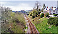
Site of Evershot station, 1995
View southward, towards Dorchester and Weymouth: ex-GWR (London, Bristol etc.) - Westbury - Yeovil - Dorchester - Weymouth main line. The station was closed 3/10/66 and the line singled about that time. This was the summit of a stiff climb in both directions. (Cf. Image]).
Image: © Ben Brooksbank
Taken: 20 Apr 1995
0.06 miles
7
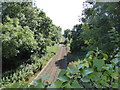
Bristol to Weymouth rail line, looking southward from Holywell
Compare photo with ST5904 : Site of Evershot station 1995.
Image: © Maurice D Budden
Taken: 16 Aug 2016
0.08 miles
8
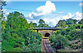
Evershot Tunnel
View northward of the south portal, with the A37 bridge crossing in front of it: ex-GWR (London/Bristol) - Westbury - Yeovil - Weymouth secondary main line. The line had been singled in May 1968; Evershot station (behind the camera) having been closed 3/10/66.
Image: © Ben Brooksbank
Taken: 6 Sep 2013
0.09 miles