IMAGES TAKEN NEAR TO
Cattistock, DORCHESTER, DT2 0JL
Introduction
This page details the photographs taken nearby to DT2 0JL by members of the Geograph project.
The Geograph project started in 2005 with the aim of publishing, organising and preserving representative images for every square kilometre of Great Britain, Ireland and the Isle of Man.

There are currently over 7.5m images from over14,400 individuals and you can help contribute to the project by visiting https://www.geograph.org.uk
Image Map
Images are licensed for reuse under creativecommons.org/licenses/by-sa/2.0
Notes
- Clicking on the map will re-center to the selected point.
- The higher the marker number, the further away the image location is from the centre of the postcode.
Image Listing (94 Images Found)
Images are licensed for reuse under creativecommons.org/licenses/by-sa/2.0
Image
Details
Distance
2
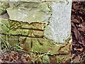
Benchmark on ruined building, Cattistock
Ordnance Survey benchmark, described on database at http://www.bench-marks.org.uk/bm64150. See also Image
Image: © Becky Williamson
Taken: 10 Feb 2015
0.03 miles
3
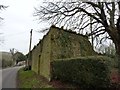
Ruined building, Hindover, Cattistock
There is an Ordnance Survey benchmark on this building. For description, see http://www.bench-marks.org.uk/bm64150. See also Image
Image: © Becky Williamson
Taken: 10 Feb 2015
0.04 miles
4
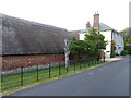
Fuller's Earth, Cattistock
A grade 2 listed house dating from 1750, extended 1820. The house was originally occupied by the Huntsman of the Cattistock Hunt, one of the most famous in England, and the adjoining buildings nearer the camera were kennels. Subsequently the house was occupied by a Colonel Fuller, a joint Master of the Hunt, hence the name of the house formed by a play on words. Fuller's Earth is now operated as a very superior bed and breakfast establishment.
Image: © Oliver Dixon
Taken: 24 Jun 2014
0.06 miles
5
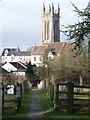
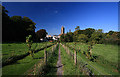
Cattistock: footpath to the church
A footpath leading from the south end of the village, towards the parish church whose tower imposes in the distance.
Image: © Chris Downer
Taken: 23 Jan 2011
0.06 miles
6
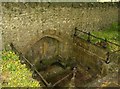
Sunken Spring in Cattistock Churchyard
Like many such places, people have thrown coins into the spring, believing that it will bring them luck.
Image: © Graham Horn
Taken: 7 May 2007
0.07 miles
7
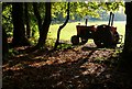
Cattistock Cricket Field
The old tractor used for pulling the lawn mowers stands quietly amongst the trees at the edge of the village cricket field in the late autumn sun.
Image: © Nigel Mykura
Taken: 12 Oct 2008
0.08 miles
9

Cattistock: detail of Cattistock Halt signpost
A close-up of the finial on the Image, showing the location name and six-figure grid reference.
Image: © Chris Downer
Taken: 23 Jan 2011
0.10 miles
10
Cattistock Church from the public footpath
Image: © Mike Searle
Taken: 26 Sep 2008
0.10 miles