IMAGES TAKEN NEAR TO
Higher Drove, DORCHESTER, DT2 0GA
Introduction
This page details the photographs taken nearby to Higher Drove, DT2 0GA by members of the Geograph project.
The Geograph project started in 2005 with the aim of publishing, organising and preserving representative images for every square kilometre of Great Britain, Ireland and the Isle of Man.

There are currently over 7.5m images from over14,400 individuals and you can help contribute to the project by visiting https://www.geograph.org.uk
Image Map
Images are licensed for reuse under creativecommons.org/licenses/by-sa/2.0
Notes
- Clicking on the map will re-center to the selected point.
- The higher the marker number, the further away the image location is from the centre of the postcode.
Image Listing (5 Images Found)
Images are licensed for reuse under creativecommons.org/licenses/by-sa/2.0
Image
Details
Distance
1
Mobile telephony mast on Higher Drove road
Operated by Crown Castle International
Image: © Tim Heaton
Taken: 25 Jan 2017
0.16 miles
2
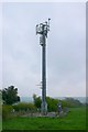
Mobile Phone Mast near Chilfrome
This mast is just east of the village on Higher Drove the road that leads out to the A356 Crewkerne to Dorchester road.
Image: © Nigel Mykura
Taken: 18 Apr 2009
0.19 miles
3
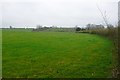
Fields at Grove Stall Farm
View north towards the farm across the fields next the track that leads to it from Chilfrome.
Image: © Nigel Mykura
Taken: 18 Apr 2009
0.24 miles
5
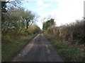
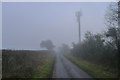
Higher Drove, Chilfrome
Leading to the A356.
Image: © Becky Williamson
Taken: 4 Feb 2018
0.24 miles