IMAGES TAKEN NEAR TO
Wynford Eagle, DORCHESTER, DT2 0EX
Introduction
This page details the photographs taken nearby to DT2 0EX by members of the Geograph project.
The Geograph project started in 2005 with the aim of publishing, organising and preserving representative images for every square kilometre of Great Britain, Ireland and the Isle of Man.

There are currently over 7.5m images from over14,400 individuals and you can help contribute to the project by visiting https://www.geograph.org.uk
Image Map (Loading...)


Getting Data...Please wait
Leaflet Map data © OpenStreetMap
Images are licensed for reuse under creativecommons.org/licenses/by-sa/2.0
Notes
- Clicking on the map will re-center to the selected point.
- The higher the marker number, the further away the image location is from the centre of the postcode.
Image Listing (4 Images Found)
Images are licensed for reuse under creativecommons.org/licenses/by-sa/2.0
Image
Details
Distance
1
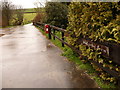
Wynford Eagle: driveway to Shatcombe Farm
Shatcombe Farm is a mile or so southwest of the centre of Wynford Eagle. For a close-up of the rather splendid little postbox, see Image
Image: © Chris Downer
Taken: 3 Apr 2010
0.00 miles
2
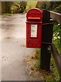
Wynford Eagle: postbox № DT2 3, Shatcombe Farm
This little George V-reign postbox is attached to a short wooden post at the Image – the posting slot is at thigh level. It is emptied at 9 o'clock each morning, except Sunday.
Image: © Chris Downer
Taken: 3 Apr 2010
0.00 miles
3
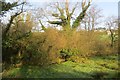
Stream, Higher Wynford
With a neighbouring water meadow.
Image: © Richard Webb
Taken: 8 Apr 2015
0.04 miles
4
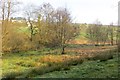
Damp valley floor
Below Shatcombe Farm near Wynford Eagle. A contrast to the dry sheep pastures on the surrounding slopes.
Image: © Richard Webb
Taken: 8 Apr 2015
0.08 miles