IMAGES TAKEN NEAR TO
Wynford Eagle, DORCHESTER, DT2 0EU
Introduction
This page details the photographs taken nearby to DT2 0EU by members of the Geograph project.
The Geograph project started in 2005 with the aim of publishing, organising and preserving representative images for every square kilometre of Great Britain, Ireland and the Isle of Man.

There are currently over 7.5m images from over14,400 individuals and you can help contribute to the project by visiting https://www.geograph.org.uk
Image Map (Loading...)


Getting Data...Please wait
Leaflet Map data © OpenStreetMap
Images are licensed for reuse under creativecommons.org/licenses/by-sa/2.0
Notes
- Clicking on the map will re-center to the selected point.
- The higher the marker number, the further away the image location is from the centre of the postcode.
Image Listing (6 Images Found)
Images are licensed for reuse under creativecommons.org/licenses/by-sa/2.0
Image
Details
Distance
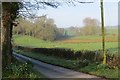
1
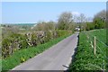
Road near Wynford Eagle
A quiet stretch of the road leading to Wynford Eagle from Eggardon Hill
Image: © Nigel Mykura
Taken: 19 Apr 2009
0.00 miles
2
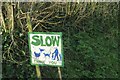
Homemade sign, Wynford Eagle
Rather a good one.
Image: © Richard Webb
Taken: 8 Apr 2015
0.02 miles
3
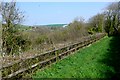
Countryside near Wynford Eagle
This neat fencing and hedging is round woods between Brookside Farm and Wynford House.
Image: © Nigel Mykura
Taken: 19 Apr 2009
0.09 miles
4
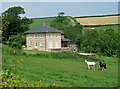
House on the road southwest of Wynford Eagle
Image: © Mike Searle
Taken: 10 Jun 2007
0.16 miles
5
Wynford Eagle to Compton road
Ascending a chalk valley.
Image: © Richard Webb
Taken: 8 Apr 2015
0.16 miles
6

Field, Wynford Eagle
Very much sheep country here. The hanger is Winholes Plantation.
Image: © Richard Webb
Taken: 8 Apr 2015
0.17 miles