IMAGES TAKEN NEAR TO
Stowey Street, DORCHESTER, DT1 3RW
Introduction
This page details the photographs taken nearby to Stowey Street, DT1 3RW by members of the Geograph project.
The Geograph project started in 2005 with the aim of publishing, organising and preserving representative images for every square kilometre of Great Britain, Ireland and the Isle of Man.

There are currently over 7.5m images from over14,400 individuals and you can help contribute to the project by visiting https://www.geograph.org.uk
Image Map
Images are licensed for reuse under creativecommons.org/licenses/by-sa/2.0
Notes
- Clicking on the map will re-center to the selected point.
- The higher the marker number, the further away the image location is from the centre of the postcode.
Image Listing (145 Images Found)
Images are licensed for reuse under creativecommons.org/licenses/by-sa/2.0
Image
Details
Distance
1
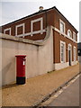
Poundbury: postbox № DT1 300, Paceycombe Way
This large, modern postbox receives its final collection at 5pm on weekdays and at 11:30am on Saturdays.
Image: © Chris Downer
Taken: 10 Apr 2010
0.01 miles
2
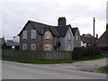
Cottages, Poundbury, Dorchester
This is one of the original estate cottages of the Poundbury Estate that existed when Poundbury was just a couple of farms. It is marked with the three feathers and "Ich Dien" crest of the Prince of Wales. Originally this estate would have belonged to every Prince of Wales and they would have just taken the rental income, but the present incumbent found he could make much more money by selling off the land for housing and thus finance his family's luxury lifestyle.
Image: © Nigel Mykura
Taken: 1 Mar 2011
0.03 miles
3
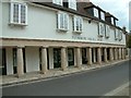
Poundbury Village Store
The Poundbury Community is a new urban development of Houses, Cottages, Shops & Light Industry, designed for the Prince of Wales by Architect Leon Krier on the outskirts of Dorchester, Dorset, England.
Image: © Stuart Buchan
Taken: 8 Jul 2005
0.04 miles
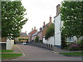
4

Faux-Georgian terraced houses in Poundbury
Image: © Sarah Charlesworth
Taken: 15 Nov 2010
0.06 miles
5
Paceycombe Way, Poundbury
Paceycombe Way is a residential street in the recently-developed "urban village" of Poundbury in Dorset.
Image: © Malc McDonald
Taken: 18 Aug 2020
0.06 miles
6
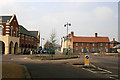
Roundabout, Poundbury
Roundabout on the Bridport Road at the top of Dinham Walk showing latest development.
Image: © Marilyn Peddle
Taken: 30 Mar 2007
0.06 miles
7
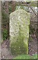
Old Milestone by the B3150, Bridport Road, Poundbury, Dorchester
Carved stone post by the B3150, in parish of DORCHESTER (WEST DORSET District), opposite Poundbury Estate, by the road, on South side of road, nearly opposite Highdown Avenue. Dorset 1 (limestone), erected by the Harnham, Blandford & Dorchester turnpike trust in the 19th century.
Inscription reads:-
Dorchester
1
Bridport
14
Carved benchmark on bottom of front face.
Milestone Society National ID: DO_BPDO14.
Image: © Mike Richards
Taken: 11 Sep 2002
0.07 miles
8

Fountain on the Green , Poundbury, Dorchester
This fountain is on the Poundbury village green, outside a row of shops which includes a cafe. It is just off the Bridport Road which is just visible at the extreme left. The Bridport Road was the main western thoroughfare out of Dorchester before Poundbury was built.
Image: © Nigel Mykura
Taken: 1 Mar 2011
0.07 miles
9
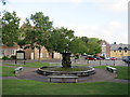
Fountain in Poundbury
A fountain in the recently-built "urban village" of Poundbury, in Dorset.
Image: © Malc McDonald
Taken: 18 Aug 2020
0.07 miles
10
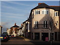
Burgundy Iris
Upmarket corner shop in the upmarket urban development at Poundbury.
http://www.poundbury.org.uk/
Image: © Colin Smith
Taken: 13 Jan 2012
0.08 miles