IMAGES TAKEN NEAR TO
Abbey Court, DORCHESTER, DT1 3FL
Introduction
This page details the photographs taken nearby to Abbey Court, DT1 3FL by members of the Geograph project.
The Geograph project started in 2005 with the aim of publishing, organising and preserving representative images for every square kilometre of Great Britain, Ireland and the Isle of Man.

There are currently over 7.5m images from over14,400 individuals and you can help contribute to the project by visiting https://www.geograph.org.uk
Image Map
Images are licensed for reuse under creativecommons.org/licenses/by-sa/2.0
Notes
- Clicking on the map will re-center to the selected point.
- The higher the marker number, the further away the image location is from the centre of the postcode.
Image Listing (65 Images Found)
Images are licensed for reuse under creativecommons.org/licenses/by-sa/2.0
Image
Details
Distance
1

New housing, Dorchester
A development called Poundbury, named after Poundbury Farm, which survives in the middle. The farm in turn was named after the ancient fort, some way behind the camera.
Image: © Robin Webster
Taken: 4 Jun 2017
0.09 miles
2

Poundbury North East Quadrant development
Photo from the edge of the recreational field to the east of the development north of Peverell Avenue East. Peverell Avenue is on the left edge of the picture while the steel frame building and tower cranes are at Queen Mother Square.
Image: © John Stephen
Taken: 24 Mar 2015
0.13 miles
4

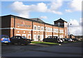
Dorset Cereals, Poundbury
One of the factories within the Poundbury project.
To quote from their website: "The Dorset Cereals factory was designed by a local architect but with considerable input by Leon Krier, an international champion of traditional urban design appointed by the Prince of Wales for his Poundbury project. Whilst the factory exterior is of stunning design, encouraging impressive comments from visitors, the interior has been designed specifically as a cereal factory and fitted out to the highest food processing standards using the best food grade materials and state of the art machinery. The factory is approved to grade ‘A’ EFSIS (European Food Safety and Inspection Service) to the Higher Level, the highest achievable food standard. Dorset Cereals has received the Queen's Award for Enterprise 2006 in recognition of its export achievement in sending its healthy breakfast range all over the world."
Image: © Richard Dorrell
Taken: 22 Mar 2010
0.16 miles
5
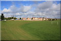
Poundbury North East Quadrant or Phase 4
View NW from playing field area to the N of Peverell Avenue East. The cranes on the left skyline are at Queen Mother Square.
Image: © John Stephen
Taken: 15 Sep 2015
0.16 miles

7

Queen Mother Square, Poundbury
Queen Mother Square in Poundbury, near Dorchester.
The buildings are built to look classical, but were built in the 2010s.
Image: © Malc McDonald
Taken: 18 Aug 2020
0.17 miles
8

Dorset Cereals
Industrial development in the largely residential area of Poundbury, Dorchester.
http://www.poundbury.org.uk/
Image: © Colin Smith
Taken: 13 Jan 2012
0.17 miles
9

Dorset Cereals factory, Poundbury
A business with credentials to match the ethos of the Poundbury project. Jolly good products too!
Image: © Jonathan Billinger
Taken: 18 Feb 2010
0.17 miles
10

Strathmore House under construction
Luxury apartment block under construction at Poundbury's Queen Mother Square. Note the columns of the façade. Strathmore House, will boast eight apartments above two shops to complete the east side of Queen Mother Square.
Image: © John Stephen
Taken: 24 Mar 2015
0.17 miles