IMAGES TAKEN NEAR TO
Dukes Parade, DORCHESTER, DT1 3EA
Introduction
This page details the photographs taken nearby to Dukes Parade, DT1 3EA by members of the Geograph project.
The Geograph project started in 2005 with the aim of publishing, organising and preserving representative images for every square kilometre of Great Britain, Ireland and the Isle of Man.

There are currently over 7.5m images from over14,400 individuals and you can help contribute to the project by visiting https://www.geograph.org.uk
Image Map
Images are licensed for reuse under creativecommons.org/licenses/by-sa/2.0
Notes
- Clicking on the map will re-center to the selected point.
- The higher the marker number, the further away the image location is from the centre of the postcode.
Image Listing (32 Images Found)
Images are licensed for reuse under creativecommons.org/licenses/by-sa/2.0
Image
Details
Distance
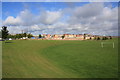
1

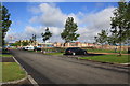
New housing, Dorchester
A development called Poundbury, named after Poundbury Farm, which survives in the middle. The farm in turn was named after the ancient fort, some way behind the camera.
Image: © Robin Webster
Taken: 4 Jun 2017
0.15 miles
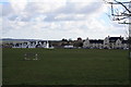
2

Poundbury North East Quadrant development
Photo from the edge of the recreational field to the east of the development north of Peverell Avenue East. Peverell Avenue is on the left edge of the picture while the steel frame building and tower cranes are at Queen Mother Square.
Image: © John Stephen
Taken: 24 Mar 2015
0.17 miles
3
Poundbury NE Quadrant from Peverell Avenue East
Development progressing apace.The cranes on the left are at Queen Mother Square.
Image: © John Stephen
Taken: 15 Sep 2015
0.18 miles
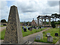
4
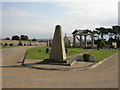
Poundbury Cemetery
At the top of Poundbury Hill, opposite the hill fort; dominated by a square colonnade bearing verses from the Bible and Dorset poets Thomas Hardy and William Barnes. The cemetery opened in 2001, so is not over-populated. http://www.dorchester-tc.gov.uk/docs/downloads/PyCemyLeaf.pdf
Image: © Mike Faherty
Taken: 15 Sep 2009
0.18 miles
5
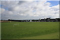
Poundbury Playing Fields
Poundbury Playing Fields north of Peverell Avenue East looking NE with cemetery at far left horizon.
Image: © John Stephen
Taken: 15 Sep 2015
0.18 miles
6
Circular shelter by a Poundbury recreation ground
Image: © Sarah Charlesworth
Taken: 15 Nov 2010
0.19 miles
7
Poundbury North East Quadrant or Phase 4
View NW from playing field area to the N of Peverell Avenue East. The cranes on the left skyline are at Queen Mother Square.
Image: © John Stephen
Taken: 15 Sep 2015
0.19 miles
8
Poundbury Recreation Field
Looking generally east towards the Dorchester Water Tower.
Image: © John Stephen
Taken: 24 Mar 2015
0.19 miles
9
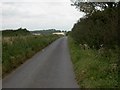
Poundbury, Roman road
Now a quiet country road, once the Roman thoroughfare from Dorchester to Silchester.
Image: © Mike Faherty
Taken: 15 Sep 2009
0.20 miles
10
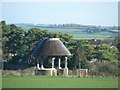
Poundbury Cemetery
Established in the 1990s, this has some unusual features, such as the temple-like building. This has a chamber beneath it for shared deposition of ashes.
Image: © Robin Webster
Taken: 4 Jun 2017
0.20 miles