IMAGES TAKEN NEAR TO
Olga Road, DORCHESTER, DT1 2LX
Introduction
This page details the photographs taken nearby to Olga Road, DT1 2LX by members of the Geograph project.
The Geograph project started in 2005 with the aim of publishing, organising and preserving representative images for every square kilometre of Great Britain, Ireland and the Isle of Man.

There are currently over 7.5m images from over14,400 individuals and you can help contribute to the project by visiting https://www.geograph.org.uk
Image Map (Loading...)


Getting Data...Please wait
Leaflet Map data © OpenStreetMap
Images are licensed for reuse under creativecommons.org/licenses/by-sa/2.0
Notes
- Clicking on the map will re-center to the selected point.
- The higher the marker number, the further away the image location is from the centre of the postcode.
Image Listing (278 Images Found)
Images are licensed for reuse under creativecommons.org/licenses/by-sa/2.0
Image
Details
Distance
1

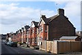
Dagmar Road, Dorchester
Houses on the south side of Dagmar Road, viewed from the corner of Alexandra Road.
Image: © Jaggery
Taken: 22 Jun 2014
0.03 miles
2

Dagmar Rd
This is a short street consisting of various types of terraced housing , most of it Victorian. It has the Gurkah Pub at one end (formerly the Cornwall) close to Dorchester west station and the Victoria pub at the other at Maud Rd.
Image: © Nigel Mykura
Taken: 18 Dec 2010
0.05 miles
3
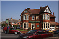
Olga Rd, Dorchester
View west along Victorian terraced houses of Olga Rd from close to its junction with Alexandra Rd. Maud Rd with its little row of shops can be seen at the far end.
Image: © Nigel Mykura
Taken: 1 Mar 2011
0.05 miles
4
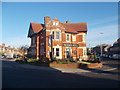
Dorchester: the Victoria Hotel
A fine building occupying the corner plot of Maud Road (foreground), Dagmar Road (left) and Olga Road (right). It is dated 1899 along with the Eldridge Pope brewery coat of arms (above the word HOTEL) and, like many of that brewery's pubs, is now run by Marston's.
Image: © Chris Downer
Taken: 31 Oct 2015
0.05 miles
5

Alexandra Road houses, Dorchester
Looking south from the corner of Dagmar Road. http://www.geograph.org.uk/photo/4040372
Image: © Jaggery
Taken: 22 Jun 2014
0.05 miles
6
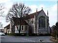
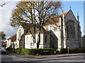
St Mary's Church
This spireless church is on the Junction of Alexander Rd and Edward Rd on the Victoria Park estate.
Image: © Nigel Mykura
Taken: 1 Mar 2011
0.06 miles
7

Pollarded lime tree, in Alexandra Road
Image: © Roger Cornfoot
Taken: 17 Nov 2009
0.06 miles
8
Victoria Hotel
The Victoria Hotel public house in Maud Road.
Image: © Marilyn Peddle
Taken: 26 Mar 2007
0.06 miles
10
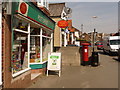
Dorchester: Victoria Park Post Office and postbox № DT1 109
This Edward VII-reign postbox is reflected in the window of the post office on a sunny Saturday lunchtime. The scheduled last collection times of the postbox are 5:15pm on weekdays and 11:30am on Saturdays, although the postman made the collection a couple of minutes after this photo was taken, at just gone noon.
Image: © Chris Downer
Taken: 10 Apr 2010
0.07 miles