IMAGES TAKEN NEAR TO
Louise Road, DORCHESTER, DT1 2LU
Introduction
This page details the photographs taken nearby to Louise Road, DT1 2LU by members of the Geograph project.
The Geograph project started in 2005 with the aim of publishing, organising and preserving representative images for every square kilometre of Great Britain, Ireland and the Isle of Man.

There are currently over 7.5m images from over14,400 individuals and you can help contribute to the project by visiting https://www.geograph.org.uk
Image Map (Loading...)


Getting Data...Please wait
Leaflet Map data © OpenStreetMap
Images are licensed for reuse under creativecommons.org/licenses/by-sa/2.0
Notes
- Clicking on the map will re-center to the selected point.
- The higher the marker number, the further away the image location is from the centre of the postcode.
Image Listing (47 Images Found)
Images are licensed for reuse under creativecommons.org/licenses/by-sa/2.0
Image
Details
Distance
1
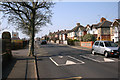
Coburg Road
Coburg Road showing the new addition of traffic calming bumps outside Dorchester Middle School.
Image: © Marilyn Peddle
Taken: 26 Mar 2007
0.08 miles
2
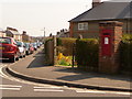
Dorchester: postbox № DT1 149, Marie Road
This George V-reign postbox is set into a brick pillar on the corner of Marie Road (many of the streets in this vicinity are named after girls' names) and Lorne Road. It is emptied finally at 5:15pm on weekdays and at 11:30am on Saturdays.
Image: © Chris Downer
Taken: 10 Apr 2010
0.09 miles
3
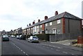
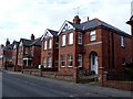
Lorne Road Dorchester
One of the sections of terraced housing that line this long road off Maud Road in the Victoria Park area.
Image: © Nigel Mykura
Taken: 1 Mar 2011
0.09 miles
4
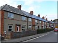
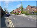
Marie Rd, Dorchester
View north along Marie Rd. These terraced houses are close to its Junction with Cambridge Rd a long street running west from Maud Rd
Image: © Nigel Mykura
Taken: 1 Mar 2011
0.09 miles
5
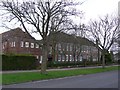
Dorchester Middle School
DMS is one of two middle schools in Dorchester whose pupils move on to Thomas Hardy School and which is only a few hundred yards up Queens Avenue from this school.
Image: © Nigel Mykura
Taken: 1 Mar 2011
0.11 miles
6
Lorne Rd Dorchester
Lorne Rd is a long residential road in Victoria Park consisting of terraced and semi detached houses from the Victorian, Edwardian and mid war periods.
Image: © Nigel Mykura
Taken: 1 Mar 2011
0.13 miles
7
Marie Road, Dorchester
A residential road west of the centre
Image: © David Smith
Taken: 1 Oct 2020
0.14 miles
8
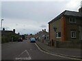
Damers Rd Dorchester
Looking west along Damers Rd from its junction with Maud Rd
Image: © Nigel Mykura
Taken: 3 Apr 2008
0.14 miles
9
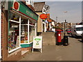
Dorchester: Victoria Park Post Office and postbox № DT1 109
This Edward VII-reign postbox is reflected in the window of the post office on a sunny Saturday lunchtime. The scheduled last collection times of the postbox are 5:15pm on weekdays and 11:30am on Saturdays, although the postman made the collection a couple of minutes after this photo was taken, at just gone noon.
Image: © Chris Downer
Taken: 10 Apr 2010
0.15 miles
10
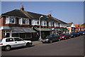
Maud Road
Row of shops in Maud Road including a bakers, chemist Post Office and General stores besides others. A busy and thriving area of Dorchester.
Image: © Marilyn Peddle
Taken: 26 Mar 2007
0.15 miles