IMAGES TAKEN NEAR TO
Ashley Road, DORCHESTER, DT1 2DJ
Introduction
This page details the photographs taken nearby to Ashley Road, DT1 2DJ by members of the Geograph project.
The Geograph project started in 2005 with the aim of publishing, organising and preserving representative images for every square kilometre of Great Britain, Ireland and the Isle of Man.

There are currently over 7.5m images from over14,400 individuals and you can help contribute to the project by visiting https://www.geograph.org.uk
Image Map (Loading...)


Getting Data...Please wait
Leaflet Map data © OpenStreetMap
Images are licensed for reuse under creativecommons.org/licenses/by-sa/2.0
Notes
- Clicking on the map will re-center to the selected point.
- The higher the marker number, the further away the image location is from the centre of the postcode.
Image Listing (395 Images Found)
Images are licensed for reuse under creativecommons.org/licenses/by-sa/2.0
Image
Details
Distance
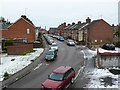
1
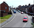
Cromwell Rd
This is a short residential road consisting of Victorian terraced housing. It runs between Monmouth Rd and Dorchester South Station and has the railway foot bridge at its northern end.
Image: © Nigel Mykura
Taken: 1 Jan 2011
0.02 miles
2
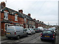
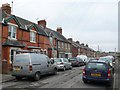
Terraced Houses Ashley Rd
These Victorian terraced houses are on the east side of Ashley road which is a short cul-de-sac off Monmouth Rd. Several have already had their fronts smartened with plastic UPVC fascias which is why one of them is currently covered in scaffolding.
Image: © Nigel Mykura
Taken: 4 Feb 2010
0.03 miles
3
Cromwell Rd
View north along the victorian terraced houses of Cromwell Rd from close to its junction with Monmouth Rd. The foot bridge at Dorchester South station can be seen at the end of the road.
Image: © Nigel Mykura
Taken: 1 Jan 2011
0.03 miles
4
Cromwell Road, Dorchester
Viewed from Dorchester South railway station footbridge. http://www.geograph.org.uk/photo/4591025
Image: © Jaggery
Taken: 22 Jun 2014
0.03 miles
5
Cromwell Rd
Cromwell Rd is a short side road of victorian terraced houses leading off Monmouth Rd north towards Dorchester South Station. This is the view south from the southern end of the station footbridge which is just in SY6990
Image: © Nigel Mykura
Taken: 10 Jan 2010
0.03 miles
6
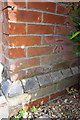
Benchmark on #1 Ashley Road
Ordnance Survey cut mark benchmark described on the Bench Mark Database at http://www.bench-marks.org.uk/bm45198
Image: © Roger Templeman
Taken: 11 Sep 2012
0.03 miles
7
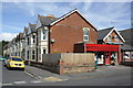
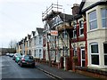
Junction of Ashley Road and Monmouth Road
There is an OS benchmark Image on the closest house below its satellite dish. The general shop was once a post office.
Image: © Roger Templeman
Taken: 11 Sep 2012
0.03 miles
8
Line towards Weymouth, Dorchester South Railway Station
Image: © JThomas
Taken: 23 Mar 2022
0.04 miles
9

Railway towards Dorchester South railway station
Looking NE from this http://www.geograph.org.uk/photo/4045258 bridge. This route uses electric trains powered by a third rail.
Image: © Jaggery
Taken: 22 Jun 2014
0.04 miles
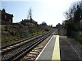
10
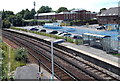
SW end of Dorchester South railway station
At this end of the station, platform 1 extends 70 metres further than platform 2.
The white vans are in a U-Drive compound. http://www.geograph.org.uk/photo/4591031
Image: © Jaggery
Taken: 22 Jun 2014
0.04 miles