IMAGES TAKEN NEAR TO
South Court Avenue, DORCHESTER, DT1 2DA
Introduction
This page details the photographs taken nearby to South Court Avenue, DT1 2DA by members of the Geograph project.
The Geograph project started in 2005 with the aim of publishing, organising and preserving representative images for every square kilometre of Great Britain, Ireland and the Isle of Man.

There are currently over 7.5m images from over14,400 individuals and you can help contribute to the project by visiting https://www.geograph.org.uk
Image Map
Images are licensed for reuse under creativecommons.org/licenses/by-sa/2.0
Notes
- Clicking on the map will re-center to the selected point.
- The higher the marker number, the further away the image location is from the centre of the postcode.
Image Listing (293 Images Found)
Images are licensed for reuse under creativecommons.org/licenses/by-sa/2.0
Image
Details
Distance
1
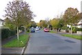
South Court Avenue
Looking west between Herringston Rd and Rothesay Rd
Image: © Nigel Mykura
Taken: 10 Oct 2008
0.02 miles
2
South Court Avenue Dorchester
Close to the junction with Rothesay Rd looking west.
Image: © Nigel Mykura
Taken: 10 Oct 2008
0.04 miles
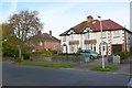
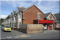
3
Dorchester: former Monmouth Road Post Office and postbox № DT1 15
The post office here closed for good on 31 October 2008, after 83 years' service. The shop appears to be clinging on to business; it is open from 9am till noon, according to a notice on the door.
Image: © Chris Downer
Taken: 10 Apr 2010
0.05 miles
4
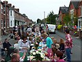
Monmouth Rd Big Lunch Street Party
Organised by local residents after an idea from the Eden Project. Part of the street was closed off between 10am and 6pm and chairs and tables were set up in the road. Everyone brought food to share, and steady drizzle after an hour or so did nothing to dampen the community spirit.
Image: © Nigel Mykura
Taken: 5 Jun 2011
0.06 miles
5
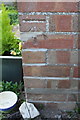
Benchmark on #57 South Court Avenue
Ordnance Survey cut mark benchmark described on the Bench Mark Database at http://www.bench-marks.org.uk/bm51589
Image: © Roger Templeman
Taken: 20 Sep 2013
0.06 miles
6
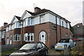
Semi-detached houses on South Court Avenue
There is an OS benchmark Image on the side of the nearest house at its front corner
Image: © Roger Templeman
Taken: 20 Sep 2013
0.06 miles
7
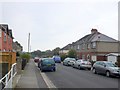
Rothesay Rd Dorchester
Looking south from near Monmouth Rd
Image: © Nigel Mykura
Taken: 15 Sep 2008
0.06 miles
8
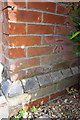
Benchmark on #1 Ashley Road
Ordnance Survey cut mark benchmark described on the Bench Mark Database at http://www.bench-marks.org.uk/bm45198
Image: © Roger Templeman
Taken: 11 Sep 2012
0.07 miles
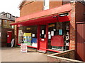
9
Junction of Ashley Road and Monmouth Road
There is an OS benchmark Image on the closest house below its satellite dish. The general shop was once a post office.
Image: © Roger Templeman
Taken: 11 Sep 2012
0.07 miles
10
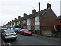
Terraced Housing on Cromwell Rd
These Victorian terraced houses are on the east side of Cromwell Rd close to the junction with Monmouth Rd.
Image: © Nigel Mykura
Taken: 4 Feb 2010
0.07 miles