IMAGES TAKEN NEAR TO
Herringston Road, DORCHESTER, DT1 2BS
Introduction
This page details the photographs taken nearby to Herringston Road, DT1 2BS by members of the Geograph project.
The Geograph project started in 2005 with the aim of publishing, organising and preserving representative images for every square kilometre of Great Britain, Ireland and the Isle of Man.

There are currently over 7.5m images from over14,400 individuals and you can help contribute to the project by visiting https://www.geograph.org.uk
Image Map (Loading...)


Getting Data...Please wait
Leaflet Map data © OpenStreetMap
Images are licensed for reuse under creativecommons.org/licenses/by-sa/2.0
Notes
- Clicking on the map will re-center to the selected point.
- The higher the marker number, the further away the image location is from the centre of the postcode.
Image Listing (168 Images Found)
Images are licensed for reuse under creativecommons.org/licenses/by-sa/2.0
Image
Details
Distance
1
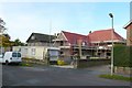
Herringston Rd Dorchester
A new house being squeezed in among the much older houses in this sought after part of Dorchester.
Image: © Nigel Mykura
Taken: 10 Oct 2008
0.01 miles
2
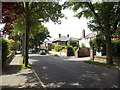
Leafy suburb in Dorchester
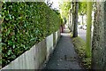
Tree-lined Herringston Road.
Image: © Jaggery
Taken: 22 Jun 2014
0.02 miles
3
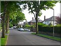
Herringston Rd Dorchester
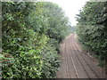
This leads south from Dorchester to Winterborne Herringston in the valley of the South Winterborne.
Image: © Nigel Mykura
Taken: 14 Jun 2008
0.03 miles
4
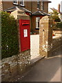
Dorchester: postbox № DT1 116, Herringston Road
This postbox is set into one of the gateposts of 20 Herringston Road and is emptied finally at 5pm on weekdays and at 11:30am on Saturdays.
Image: © Chris Downer
Taken: 10 Apr 2010
0.04 miles
5
Dorchester Junction
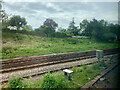
The line from Dorchester West station reduces to a single track before connection with the Dorchester South to Weymouth line.
Seen from Weymouth Avenue bridge.
Image: © Jonathan Thacker
Taken: 5 Sep 2014
0.05 miles
6
Herringston Rd, Dorchester
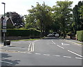
Looking south from close to the junction with South Court Avenue
Image: © Nigel Mykura
Taken: 10 Oct 2008
0.05 miles
7
The South Western Main Line
Approaching the junction with the Heart of Wessex Line in Dorchester.
Image: © Andrew Abbott
Taken: 17 Jun 2021
0.07 miles
8
Herringston Road, Dorchester
Looking south from South Court Avenue. Pointing along Herringston Road,
signs show Joseph Weld Hospice and The Winterbourne Hospital.
Image: © Jaggery
Taken: 22 Jun 2014
0.07 miles
9
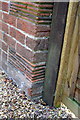
Benchmark on #27 Herringston Road
Ordnance Survey cut mark benchmark described on the Bench Mark Database at http://www.bench-marks.org.uk/bm32166
Image: © Roger Templeman
Taken: 11 Sep 2012
0.08 miles
10
Building at the eastern edge of Dorchester Cemetery
The large black cross suggests that this is a cemetery chapel, though only North Chapel http://www.geograph.org.uk/photo/4591594
and South Chapel http://www.geograph.org.uk/photo/4591588 are shown as places of worship on maps.
Image: © Jaggery
Taken: 22 Jun 2014
0.09 miles