IMAGES TAKEN NEAR TO
DORCHESTER, DT1 2AS
Introduction
This page details the photographs taken nearby to DT1 2AS by members of the Geograph project.
The Geograph project started in 2005 with the aim of publishing, organising and preserving representative images for every square kilometre of Great Britain, Ireland and the Isle of Man.

There are currently over 7.5m images from over14,400 individuals and you can help contribute to the project by visiting https://www.geograph.org.uk
Image Map (Loading...)


Getting Data...Please wait
Leaflet Map data © OpenStreetMap
Images are licensed for reuse under creativecommons.org/licenses/by-sa/2.0
Notes
- Clicking on the map will re-center to the selected point.
- The higher the marker number, the further away the image location is from the centre of the postcode.
Image Listing (308 Images Found)
Images are licensed for reuse under creativecommons.org/licenses/by-sa/2.0
Image
Details
Distance
1
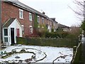
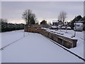
Railway Terrace
This small terrace of victorian houses face north on the southern edge of the square and sits right next to the railway line just to the east of Dorchester South station. The railway is behind the hedge on the right. There is road access only to the far end of the terrace
Image: © Nigel Mykura
Taken: 10 Jan 2010
0.02 miles
2
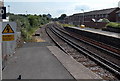
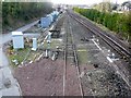
Railway east from Dorchester South railway station
Dorchester South, on the London Waterloo–Weymouth main line, is managed by South West Trains, who operate all passenger trains on this route. Trains are powered by electricity supplied by a third rail alongside each track.
Image: © Jaggery
Taken: 22 Jun 2014
0.03 miles
3
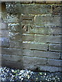
Benchmark on the side of #123 Monmouth Road
Ordnance Survey cut mark benchmark described on the Bench Mark Database at http://www.bench-marks.org.uk/bm29041
Image: © Roger Templeman
Taken: 20 Sep 2010
0.04 miles
4
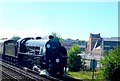
Steam in Dorchester
Locomotive 30777 described as the Cathedral Express passes through Dorchester. this was taken just east of Dorchester south station with the Brewery Square development visible prominently on the right.
Image: © Nigel Mykura
Taken: 10 Jul 2010
0.04 miles
5

Brewery Square Western Access Road.
View west from the northern end of the Culliford Rd railway bridge. The new development site at the old Eldridge Pope brewery has extremely limited access being hemmed in by the railway, Maumbury Rings and houses. There are two small access points at the eastern end of the site and these are currently being enlarged and developed. This road runs along the railway which can be seen on the left and a new road ramp will be built up to the point where Prince of Wales Rd intersects with Culliford Rd. This will result in a large increase of traffic at this junction and turn it into a five way junction instead of a four way. The old gravel track ramp that the road is replacing can still be seen on the right of the image.
( Additional information, 2015) :-The cleared area in the foreground of the image is where the apartment block known as Bridge House and also the attached Signal House now stand.
Image: © Nigel Mykura
Taken: 20 Jul 2010
0.04 miles
6
Eastern Approach Rd Brewery Square
Covered with snow and still never used by traffic this is the eastern approach road to the development which has still not been properly started. This road, which runs just north of the railtracks west of Dorchester South station, connects the sprawling site with the junction of Prince of Wales Rd and Culliford Rd.
Image: © Nigel Mykura
Taken: 3 Dec 2010
0.04 miles
7
Railway in Dorchester
View west along the track towards Dorchester South Station from the west side of the bridge where Culliford Rd crosses the tracks.
Image: © Nigel Mykura
Taken: 28 Jan 2010
0.05 miles
8
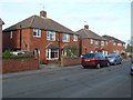
Houses in Monmouth Road
These houses are close to the eastern end and on the northern side of Monmouth Road near the junction with Culliford Road.
Image: © Nigel Mykura
Taken: 28 Jan 2010
0.05 miles
9

Treetops and Rooftops
Slate roofs of Victorian houses and blossom from an apricot tree in this view across part of Manor Park in Dorchester
Image: © Nigel Mykura
Taken: 20 Mar 2009
0.05 miles
10
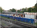
Construction of Affordable Housing
This photo shows the construction starting on a block of affordable housing. It is at the very eastern end of the "Brewery Square" development site closet to Dorchester South Station. However it has been squeezed onto a tiny patch of land between the railway lines and the eastern access road to the main site, which is not the nicest of locations. In the similar fashion to council houses of the 20th C the not so well off people are pushed to the margins. This only shows the base of the building. When it is finished it will be five storeys high and will dominate the immediate area that has no tall buildings.
Image: © Nigel Mykura
Taken: 18 Sep 2011
0.06 miles