IMAGES TAKEN NEAR TO
Grove Trading Estate, DORCHESTER, DT1 1SU
Introduction
This page details the photographs taken nearby to Grove Trading Estate, DT1 1SU by members of the Geograph project.
The Geograph project started in 2005 with the aim of publishing, organising and preserving representative images for every square kilometre of Great Britain, Ireland and the Isle of Man.

There are currently over 7.5m images from over14,400 individuals and you can help contribute to the project by visiting https://www.geograph.org.uk
Image Map (Loading...)


Getting Data...Please wait
Leaflet Map data © OpenStreetMap
Images are licensed for reuse under creativecommons.org/licenses/by-sa/2.0
Notes
- Clicking on the map will re-center to the selected point.
- The higher the marker number, the further away the image location is from the centre of the postcode.
Image Listing (67 Images Found)
Images are licensed for reuse under creativecommons.org/licenses/by-sa/2.0
Image
Details
Distance
3
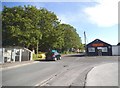
The Marabout Industrial Estate, Dorchester
Image: © David Howard
Taken: 3 Jul 2017
0.08 miles
4
Dorchester: postbox № DT1 510, Maumbury Trading Estate
This postbox, for franked mail only, is emptied finally at 6:30pm on weekdays and is closed at weekends.
Image: © Chris Downer
Taken: 10 Apr 2010
0.09 miles
5
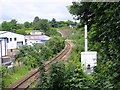
Tunnel portal, Poundbury Hill Fort
Looking North West along the railway line that connects Weymouth to Yeovil Pen Mill from Poundbury Road. The tunnel is very shallow and only about 840ft long. In other similar situations along the line it would have been a cutting but I wonder if a tunnel was built here to avoid damage to Poundbury Hill Fort which is very close to this tunnel portal?
Image: © Ian Andrews
Taken: 21 Jun 2013
0.11 miles
6
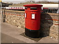
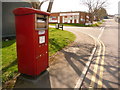
Dorchester: postbox № DT1 210, Miller?s Close
This modern, double-aperture postbox stands at the eastern entrance to an industrial and retail estate – we can see a Citroën and a Nissan car dealership behind. The box is emptied finally at 5:30pm on weekdays and at 11:30am on Saturdays.
Image: © Chris Downer
Taken: 10 Apr 2010
0.14 miles
7
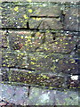
Benchmark on parapet of railway bridge on Poundbury Road
Ordnance Survey cut mark benchmark described on the Bench Mark Database at http://www.bench-marks.org.uk/bm29048
Image: © Roger Templeman
Taken: 30 Dec 2010
0.16 miles
8
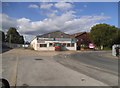
Looking down on "The Weir"
The Grove (bottom left) changes to the causeway which leaves Dorchester on the way to Yeovil. The local name of the road as it crosses the meadows is "The Weir".
Mid left, the mock tudor half-timbered building is a redundant pub - The Compasses - now a garage. The petrol station (mid right) is known as Loders.
Image: © DorsetBlogger
Taken: 29 Mar 2008
0.16 miles
9
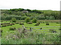
The floodplain of the River Frome
The portal of the railway tunnel entrance can just be seen in the distance.
Image: © Sarah Charlesworth
Taken: 20 May 2010
0.16 miles
10
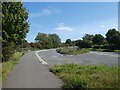
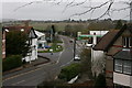
Cycle route and lay-by by A37 near Dorchester
Image: © David Smith
Taken: 26 Aug 2020
0.17 miles