IMAGES TAKEN NEAR TO
Victoria Road, DORCHESTER, DT1 1SB
Introduction
This page details the photographs taken nearby to Victoria Road, DT1 1SB by members of the Geograph project.
The Geograph project started in 2005 with the aim of publishing, organising and preserving representative images for every square kilometre of Great Britain, Ireland and the Isle of Man.

There are currently over 7.5m images from over14,400 individuals and you can help contribute to the project by visiting https://www.geograph.org.uk
Image Map
Images are licensed for reuse under creativecommons.org/licenses/by-sa/2.0
Notes
- Clicking on the map will re-center to the selected point.
- The higher the marker number, the further away the image location is from the centre of the postcode.
Image Listing (623 Images Found)
Images are licensed for reuse under creativecommons.org/licenses/by-sa/2.0
Image
Details
Distance
1

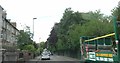
West side of Victoria Road, Dorchester
A long row of houses extending away from the fish & chips shop http://www.geograph.org.uk/photo/4040375 on the corner of Damers Road.
Image: © Jaggery
Taken: 22 Jun 2014
0.01 miles
2
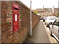
Dorchester: postbox № DT1 59, Westover Road
This Elizabeth II-reign is emptied finally at 5:30pm on weekdays and at 11:30am on Saturdays.
Image: © Chris Downer
Taken: 10 Apr 2010
0.02 miles
3

Westover Road, Dorchester
Viewed from Cornwall Road looking along Westover Road towards Victoria Road, 60 metres ahead.
Image: © Jaggery
Taken: 22 Jun 2014
0.02 miles
4
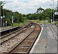
Two tracks into one north of Dorchester West railway station
The Heart of Wessex Line becomes single track ahead.
Image: © Jaggery
Taken: 22 Jun 2014
0.03 miles
5
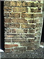
Benchmark on garage in Victoria Road
Ordnance Survey cut mark benchmark described on the Bench Mark Database at http://www.bench-marks.org.uk/bm25181
Image: © Roger Templeman
Taken: 20 Sep 2010
0.03 miles
6

Two tracks into one north of Dorchester West railway station
The twin tracks of the Heart of Wessex Line merge into one track ahead. The next station in this direction is Maiden Newton on the route to Bristol via Castle Cary, Yeovil, Westbury and Bath.
Image: © Jaggery
Taken: 22 Jun 2014
0.03 miles
7
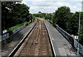
North side of Dorchester West railway station
Viewed from the station footbridge. http://www.geograph.org.uk/photo/4489116 The photo shows the sides of, and the girder at the top of,
the bridge over the B3144. Beyond the platforms, the Heart of Wessex Line becomes single track.
Image: © Jaggery
Taken: 22 Jun 2014
0.03 miles
8

Cornwall Road houses in Dorchester
The houses face the western edge of a park, Borough Gardens.
Image: © Jaggery
Taken: 22 Jun 2014
0.04 miles
10
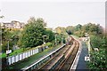
Dorchester West railway station, looking north
Image: © Jonathan Hutchins
Taken: Unknown
0.04 miles