IMAGES TAKEN NEAR TO
Ackerman Road, DORCHESTER, DT1 1NZ
Introduction
This page details the photographs taken nearby to Ackerman Road, DT1 1NZ by members of the Geograph project.
The Geograph project started in 2005 with the aim of publishing, organising and preserving representative images for every square kilometre of Great Britain, Ireland and the Isle of Man.

There are currently over 7.5m images from over14,400 individuals and you can help contribute to the project by visiting https://www.geograph.org.uk
Image Map (Loading...)


Getting Data...Please wait
Leaflet Map data © OpenStreetMap
Images are licensed for reuse under creativecommons.org/licenses/by-sa/2.0
Notes
- Clicking on the map will re-center to the selected point.
- The higher the marker number, the further away the image location is from the centre of the postcode.
Image Listing (58 Images Found)
Images are licensed for reuse under creativecommons.org/licenses/by-sa/2.0
Image
Details
Distance
1
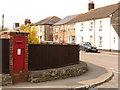
Dorchester: postbox № DT1 44, Ackerman Road
This large Edward VII-reign postbox stands on the corner of Ackerman and St. George's Roads and is emptied finally at 5:30pm on weekdays and at 11:30am on Saturdays.
Image: © Chris Downer
Taken: 10 Apr 2010
0.05 miles
2
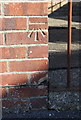
Benchmark on #31 St Georges Road
Ordnance Survey cut mark benchmark described on the Bench Mark Database at http://www.bench-marks.org.uk/bm51778
Image: © Roger Templeman
Taken: 23 Sep 2013
0.05 miles
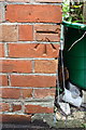
3
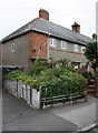
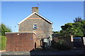
#31 St Georges Road
There is an OS benchmark Image on the side of the house in the bricks at the front corner
Image: © Roger Templeman
Taken: 23 Sep 2013
0.05 miles
4
#27 & #29 Alington Road
There is an OS benchmark Image on a milestone at the pavement end of the party fence between #25 and #27, visible in the shade at the left hand edge of the image
Image: © Roger Templeman
Taken: 23 Sep 2013
0.05 miles
5
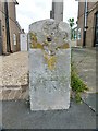
Old Milestone by the B3144, Arlington Road, Dorchester
Carved stone post with missing metal plate by the B3144, in parish of Dorchester (West Dorset District), Arlington Road, by No. 27, against front wall, on East side of road. Dorset 3 (limestone), erected by the Dorchester & Wool Turnpike Trust in the 19th century.
Inscription once read:-
(16)
(Wareham)
(Dorchester)
(1)
Carved benchmark on lower front face.
Milestone Society National ID: DO_DOWA01.
Image: © Milestone Society
Taken: 5 May 2017
0.05 miles
6
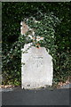
Benchmarked defaced milestone on Alington Road
Ordnance Survey cut mark benchmark described on the Bench Mark Database at http://www.bench-marks.org.uk/bm29155
Image: © Roger Templeman
Taken: 17 Aug 2011
0.06 miles
7
Benchmark on electricity substation, Prince of Wales Road
Ordnance Survey cut mark benchmark described on the Bench Mark Database at http://www.bench-marks.org.uk/bm51894
Image: © Roger Templeman
Taken: 23 Sep 2013
0.08 miles
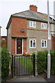
8
Electricity substation on Prince of Wales Road
There is an OS benchmark Image on the front of the right hand corner of the substation.
Image: © Roger Templeman
Taken: 23 Sep 2013
0.08 miles
9
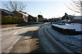
Prince of Wales Road
Unusually quiet on the roads the morning after the snow.
Image: © DorsetBlogger
Taken: 7 Feb 2009
0.08 miles
10
#55 St Georges Road
There is an OS benchmark Image above the side path on the bricks at the front corner
Image: © Roger Templeman
Taken: 23 Sep 2013
0.09 miles