IMAGES TAKEN NEAR TO
Kings Road, DORCHESTER, DT1 1NL
Introduction
This page details the photographs taken nearby to Kings Road, DT1 1NL by members of the Geograph project.
The Geograph project started in 2005 with the aim of publishing, organising and preserving representative images for every square kilometre of Great Britain, Ireland and the Isle of Man.

There are currently over 7.5m images from over14,400 individuals and you can help contribute to the project by visiting https://www.geograph.org.uk
Image Map
Images are licensed for reuse under creativecommons.org/licenses/by-sa/2.0
Notes
- Clicking on the map will re-center to the selected point.
- The higher the marker number, the further away the image location is from the centre of the postcode.
Image Listing (112 Images Found)
Images are licensed for reuse under creativecommons.org/licenses/by-sa/2.0
Image
Details
Distance
1
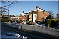
Athelstan Road
Athelstan Road leads off of Prince of Wales Rd. It is where the driving tests start from. This photo was taken from in front of the Driving Test Centre.
Image: © DorsetBlogger
Taken: 7 Feb 2009
0.03 miles
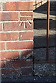
2

Building on Kings Road
There is an OS benchmark Image near one of the downpipes
Image: © Roger Templeman
Taken: 23 Sep 2013
0.03 miles
3
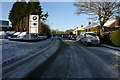
Prince of Wales Road
The Tice garage has recently been taken over by the Westerly and been renamed accordingly.
Image: © DorsetBlogger
Taken: 7 Feb 2009
0.03 miles
4
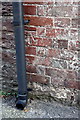
Benchmark on building on Kings Road
Ordnance Survey cut mark benchmark described on the Bench Mark Database at http://www.bench-marks.org.uk/bm52010
Image: © Roger Templeman
Taken: 23 Sep 2013
0.03 miles
5

Kings Road Fordington
Looking south down Kings Road with Icen way coming in from the right. On the left are buildings near where the Old Dairy once operated and on the right is the back of Fordington House.
Image: © Sarah Smith
Taken: 18 Jun 2009
0.04 miles
6

Fordington House - West front
Fordington House was part of a marriage settlement in 1711. The house was much larger and has been altered several times since then. The house and its grounds used to be surrounded by a high stone wall and a drive sweeping in from Icen Way. The photograph is taken from near where the stables once stood. A Mr and Mrs Barnes used to run a riding stables here in the 1950's and 60's and the paddock that was situated in front of the west front (now Lancaster Road) is where riding lessons were given!
Image: © Sarah Smith
Taken: 18 Jun 2009
0.04 miles
7

Where Icen Way flows into Kings Road Fordington
There is a junction in Kings Road on the right allowing the continuation of traffic from Icen Way to reach the London Road (B3150) without interruption. The houses at the end are near where the Old Dairy was situated.
Image: © Sarah Smith
Taken: 18 Jun 2009
0.05 miles
8

Lancaster Road Dorchester
Once the grounds of Fordington House, this area has now been redeveloped into a pleasant area in which to live.
Image: © Sarah Smith
Taken: 18 Jun 2009
0.07 miles
9
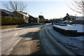
Prince of Wales Road
Unusually quiet on the roads the morning after the snow.
Image: © DorsetBlogger
Taken: 7 Feb 2009
0.07 miles
10
Benchmark on electricity substation, Prince of Wales Road
Ordnance Survey cut mark benchmark described on the Bench Mark Database at http://www.bench-marks.org.uk/bm51894
Image: © Roger Templeman
Taken: 23 Sep 2013
0.10 miles