IMAGES TAKEN NEAR TO
Holloway Road, DORCHESTER, DT1 1LQ
Introduction
This page details the photographs taken nearby to Holloway Road, DT1 1LQ by members of the Geograph project.
The Geograph project started in 2005 with the aim of publishing, organising and preserving representative images for every square kilometre of Great Britain, Ireland and the Isle of Man.

There are currently over 7.5m images from over14,400 individuals and you can help contribute to the project by visiting https://www.geograph.org.uk
Image Map
Images are licensed for reuse under creativecommons.org/licenses/by-sa/2.0
Notes
- Clicking on the map will re-center to the selected point.
- The higher the marker number, the further away the image location is from the centre of the postcode.
Image Listing (128 Images Found)
Images are licensed for reuse under creativecommons.org/licenses/by-sa/2.0
Image
Details
Distance
1
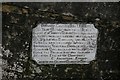
Sign on Prince's Bridge, Dorchester
I like the reference to 'ponderous carriages'! The date of the bridge's construction is uncertain, although it is thought to be nineteenth century, possibly older.
Image: © Becky Williamson
Taken: 31 Jan 2015
0.01 miles
2
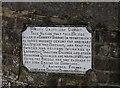
Old Bridge Marker on Princes Bridge, Mill Street, Dorchester
Bridge Weight Plate by the UC road, in parish of Dorchester (West Dorset District), Mill Street, on Princes Bridge over the mill stream.
Inscription reads:-
COUNTY COUNCIL OF DORSET.
TAKE NOTICE THAT THIS BRIDGE
(WHICH IS A COUNTY BRIDGE) IS INSUFFICIENT
TO CARRY WEIGHTS BEYOND THE ORDINARY
TRAFFIC OF THE DISTRICT; AND THAT THE
OWNERS AND PERSONS IN CHARGE OF
LOCOMOTIVE TRACTION ENGINES AND OTHER
PONDEROUS CARRIAGES ARE WARNED AGAINST
USING THE BRIDGE FOR THE PASSAGE OF
ANY SUCH ENGINE OR CARRIAGE.
E. ARCHDALL FFOOKS
CLERK OF THE COUNTY COUNCIL OF DORSET
Princes Bridge is Grade II listed.
List Entry Number: 1324033 https://historicengland.org.uk/listing/the-list/list-entry/1324033
Surveyed
Milestone Society National ID: DO_WEIDOMbr
Image: © Milestone Society
Taken: Unknown
0.02 miles
3
Benchmark on Prince's Bridge
Ordnance Survey cut mark benchmark described on the Bench Mark Database http://www.bench-marks.org.uk/bm51862
Image: © Roger Templeman
Taken: 23 Sep 2013
0.03 miles
4
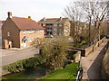
Prince's Bridge and Kings Road bridge over Mill Stream
There is an OS benchmark Image on a stone in the parapet of the near bridge (Prince's Bridge) near the left hand edge of the image. The far bridge is for the B3143.
Image: © Roger Templeman
Taken: 23 Sep 2013
0.03 miles
5
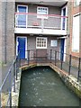
Apartments with running water, Fordington, Dorchester
These apartments are in the old mill at Fordington on the edge of Dorchester. The mill stream passes right under the building.
Image: © Nigel Mykura
Taken: 17 Jan 2008
0.03 miles
6
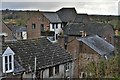
Fordington: Houses and flats in Holloway Road
Image: © Michael Garlick
Taken: 18 Apr 2019
0.03 miles
7
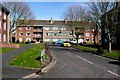
Durnover Close , Fordington
View east into this quiet residential close with small blocks of flats from Mill St.
Image: © Nigel Mykura
Taken: 16 Mar 2009
0.05 miles
8
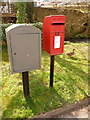
Dorchester: postbox № DT1 103 and a duck, Mill Street
This little postbox has its back to the River Frome (just visible) as it flows between Mill Street and Holloway Road. It is emptied finally at 5:30pm on weekdays and at 11:30am on Saturdays.
Alongside it is a 'drop box' (see below).
Image: © Chris Downer
Taken: 10 Apr 2010
0.06 miles
9
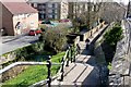
Footbridge over Fordington Mill Stream
View down to the bridge and mill stream from the top of the steps on Holloway Rd with Mill Street on the extreme left.
Image: © Nigel Mykura
Taken: 16 Mar 2009
0.07 miles
10
Dorchester: footbridge over the Frome at Mill Street
Looking across the River Frome from Holloway Road towards Mill Street, with the footbridge linking the two.
Image: © Chris Downer
Taken: 10 Apr 2010
0.07 miles