IMAGES TAKEN NEAR TO
Blandford Camp, BLANDFORD FORUM, DT11 8RJ
Introduction
This page details the photographs taken nearby to DT11 8RJ by members of the Geograph project.
The Geograph project started in 2005 with the aim of publishing, organising and preserving representative images for every square kilometre of Great Britain, Ireland and the Isle of Man.

There are currently over 7.5m images from over14,400 individuals and you can help contribute to the project by visiting https://www.geograph.org.uk
Image Map (Loading...)


Getting Data...Please wait
Leaflet Map data © OpenStreetMap
Images are licensed for reuse under creativecommons.org/licenses/by-sa/2.0
Notes
- Clicking on the map will re-center to the selected point.
- The higher the marker number, the further away the image location is from the centre of the postcode.
Image Listing (3 Images Found)
Images are licensed for reuse under creativecommons.org/licenses/by-sa/2.0
Image
Details
Distance
1
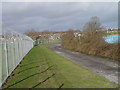
Blandford Camp
View to rear gate of the camp. The footpath used to run up through the camp but is now diverted around the perimeter fence
Image: © Brian Ironside
Taken: 14 Jan 2007
0.14 miles
2
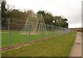
Cargo net A frame, Blandford Camp
Part of an assault course on the east side of the camp, from the perimeter footpath.
Image: © Derek Harper
Taken: 21 Nov 2008
0.15 miles
3
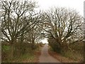
Road from Blandford Camp
One of the minor roads leading away across Monkton Down from the camp edge. But it doesn't lead to the outside world for vehicles.
Image: © Derek Harper
Taken: 21 Nov 2008
0.17 miles