IMAGES TAKEN NEAR TO
Oakwood Drive, BLANDFORD FORUM, DT11 8QT
Introduction
This page details the photographs taken nearby to Oakwood Drive, DT11 8QT by members of the Geograph project.
The Geograph project started in 2005 with the aim of publishing, organising and preserving representative images for every square kilometre of Great Britain, Ireland and the Isle of Man.

There are currently over 7.5m images from over14,400 individuals and you can help contribute to the project by visiting https://www.geograph.org.uk
Image Map
Images are licensed for reuse under creativecommons.org/licenses/by-sa/2.0
Notes
- Clicking on the map will re-center to the selected point.
- The higher the marker number, the further away the image location is from the centre of the postcode.
Image Listing (29 Images Found)
Images are licensed for reuse under creativecommons.org/licenses/by-sa/2.0
Image
Details
Distance
1
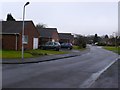
Oakwood Drive
This is a small residential road on the southern edge of Iwerne Minster consisting mainly of bungalow. It is a dead end that opens out to the A350 Blandford Rd at its northern end.
Image: © Nigel Mykura
Taken: 16 Jan 2010
0.03 miles
2
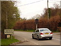
Sensitive 30 sign
This car virtually crawled past my camera, yet still set off the 30mph reminder.
However a timely reminder for a narrow, curvy, village stretch of the A350.
Image: © Simon Scurr
Taken: 20 Mar 2007
0.05 miles
3
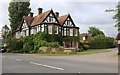
House on Aston Court, Iwerne Minster
This appears to be the original house, the ones on the little road are all new.
Image: © David Howard
Taken: 20 Jun 2020
0.08 miles
5
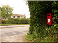
Iwerne Minster: postbox № DT11 143
A small postbox serving the southern part of Iwerne Minster, emptied daily except Sunday at 1pm (which for a Saturday is perhaps surprisingly late).
Image: © Chris Downer
Taken: 18 Jul 2009
0.10 miles
6
Old Milepost by the A350, Iwerne Minster
Cast iron post by the A350, in parish of IWERNE MINSTER (NORTH DORSET District), South of village, 50m South of 30mph signs, where overhead cables cross road, on North West side of road. Well hidden in roadside vegetation. Dorset 5 (limestone), erected by the Shaftesbury & New Road to Blandford turnpike trust in the 19th century.
Inscription reads:-
BLANDFORD
6
SHAFTESBURY
6
Milestone Society National ID: DO_BFSF06.
Image: © J Tybjerg
Taken: 12 Jan 2003
0.15 miles
7
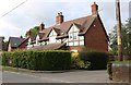
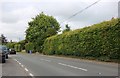
Bramley Grove, Iwerne Minster
The far house is new, this looks original, possibly a Victorian or more recent facsimile of the local design.
Image: © David Howard
Taken: 20 Jun 2020
0.16 miles
8

The Talbot Inn, Iwerne Minster
The Talbot is easy to find in the middle of the pretty village and has recently been renovated and refurbished to a high standard.
Image: © Maigheach-gheal
Taken: 2 Aug 2008
0.19 miles
9
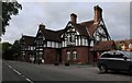
The Talbot, Iwerne Minster
All the buildings along Blandford Road here follow this design, old and new. I have seen other villages following the same design elsewhere in the south.
Image: © David Howard
Taken: 20 Jun 2020
0.19 miles
10

Weather vane, Iwerne Minster
Found on the Talbot Inn.
Image: © Maigheach-gheal
Taken: 2 Aug 2008
0.19 miles