IMAGES TAKEN NEAR TO
Glebe Court, BLANDFORD FORUM, DT11 8PQ
Introduction
This page details the photographs taken nearby to Glebe Court, DT11 8PQ by members of the Geograph project.
The Geograph project started in 2005 with the aim of publishing, organising and preserving representative images for every square kilometre of Great Britain, Ireland and the Isle of Man.

There are currently over 7.5m images from over14,400 individuals and you can help contribute to the project by visiting https://www.geograph.org.uk
Image Map
Images are licensed for reuse under creativecommons.org/licenses/by-sa/2.0
Notes
- Clicking on the map will re-center to the selected point.
- The higher the marker number, the further away the image location is from the centre of the postcode.
Image Listing (115 Images Found)
Images are licensed for reuse under creativecommons.org/licenses/by-sa/2.0
Image
Details
Distance
1
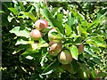
An apple a day ...
Ripening apples in Iwerne Minster.
Image: © Maigheach-gheal
Taken: 2 Aug 2008
0.07 miles
2
![Iwerne Minster houses [8]](https://s2.geograph.org.uk/geophotos/06/76/87/6768706_46779610_120x120.jpg)
Iwerne Minster houses [8]
Goose Corner and May Cottage, in Watery Lane, are a pair of brick built cottages with thatched roof, probably early 19th century. There is a modern extension on the right. Listed, grade II, with details at: https://historicengland.org.uk/listing/the-list/list-entry/1110202
Iwerne Minster is a small village on the edge of the Blackmore Vale, about 5 miles south of Shaftesbury and the same distance north of Blandford Forum. The village is within the Cranborne Chase and West Wiltshire Down Area of Outstanding Natural Beauty. There is evidence of occupation since prehistoric times. The River Iwerne flows from a spring in the middle of the village. The original Minister is now St Mary's Church and was built by the Normans on the site of an earlier church.
Image: © Michael Dibb
Taken: 10 Dec 2020
0.09 miles
3
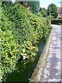
Roadside stream, Iwerne Minster
Iwerne is an ancient British (Celtic) river-name, first recorded as Iwern broc in the mid-10th century but much older than that, probably meaning 'yew-tree stream'. Iwerne Minster is recorded as Evneminstre in the Domesday Book of 1086, but its first appearance is in a Saxon charter dated 871 where it is simply ywern or hywerna. The affix is Old English mynster '(church of) a monastery' with reference to the early possession of this estate by Shaftesbury Abbey.
Image: © Maigheach-gheal
Taken: 2 Aug 2008
0.09 miles
4
![Iwerne Minster houses [7]](https://s1.geograph.org.uk/geophotos/06/76/87/6768701_0d678163_120x120.jpg)
Iwerne Minster houses [7]
Sunnyside House and attached shop, The Chalk, were originally three cottages. Late 17th or early 18th century built in brick and greatly remodelled in the early 20th century. The former shop projects as a single-storey wing to the front left. Listed, grade II, with details at: https://historicengland.org.uk/listing/the-list/list-entry/1324617
Iwerne Minster is a small village on the edge of the Blackmore Vale, about 5 miles south of Shaftesbury and the same distance north of Blandford Forum. The village is within the Cranborne Chase and West Wiltshire Down Area of Outstanding Natural Beauty. There is evidence of occupation since prehistoric times. The River Iwerne flows from a spring in the middle of the village. The original Minister is now St Mary's Church and was built by the Normans on the site of an earlier church.
Image: © Michael Dibb
Taken: 10 Dec 2020
0.10 miles
5
![Iwerne Minster houses [4]](https://s3.geograph.org.uk/geophotos/06/76/78/6767859_2c8bd0c2_120x120.jpg)
Iwerne Minster houses [4]
Now known as Brookman' Old Farm, is this former farmhouse in Watery Lane. Built in the 17th century with rubble walls and a thatched roof. There are later extensions to the rear, seen here. Listed, grade II, with https://historicengland.org.uk/listing/the-list/list-entry/1324642
Iwerne Minster is a small village on the edge of the Blackmore Vale, about 5 miles south of Shaftesbury and the same distance north of Blandford Forum. The village is within the Cranborne Chase and West Wiltshire Down Area of Outstanding Natural Beauty. There is evidence of occupation since prehistoric times. The River Iwerne flows from a spring in the middle of the village. The original Minister is now St Mary's Church and was built by the Normans on the site of an earlier church.
Image: © Michael Dibb
Taken: 10 Dec 2020
0.10 miles
6
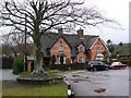
Iwerne Minster
This is a small green with one tree close to the centre of the village.This part of the village is known as The Chalk.
Image: © Nigel Mykura
Taken: 16 Jan 2010
0.10 miles
7
![Iwerne Minster houses [9]](https://s0.geograph.org.uk/geophotos/06/76/87/6768708_29a468ce_120x120.jpg)
Iwerne Minster houses [9]
Sunnyside Cottage, The Chalk, is late 18th or early 19th century. Built in rubble stone with a red brick front. Listed, grade II, with details at: https://historicengland.org.uk/listing/the-list/list-entry/1305241
Iwerne Minster is a small village on the edge of the Blackmore Vale, about 5 miles south of Shaftesbury and the same distance north of Blandford Forum. The village is within the Cranborne Chase and West Wiltshire Down Area of Outstanding Natural Beauty. There is evidence of occupation since prehistoric times. The River Iwerne flows from a spring in the middle of the village. The original Minister is now St Mary's Church and was built by the Normans on the site of an earlier church.
Image: © Michael Dibb
Taken: 10 Dec 2020
0.11 miles
8
![Iwerne Minster features [3]](https://s0.geograph.org.uk/geophotos/06/76/87/6768700_b2cbed17_120x120.jpg)
Iwerne Minster features [3]
The village sign in metal on a wooden post is located in The Chalk.
Iwerne Minster is a small village on the edge of the Blackmore Vale, about 5 miles south of Shaftesbury and the same distance north of Blandford Forum. The village is within the Cranborne Chase and West Wiltshire Down Area of Outstanding Natural Beauty. There is evidence of occupation since prehistoric times. The River Iwerne flows from a spring in the middle of the village. The original Minister is now St Mary's Church and was built by the Normans on the site of an earlier church.
Image: © Michael Dibb
Taken: 10 Dec 2020
0.11 miles
9
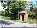
Village sign and shelter, Iwerne Minster
Attached to the shelter are the signs recording the dates when the village won the "Best Kept" village competition.
Image: © Maigheach-gheal
Taken: 2 Aug 2008
0.11 miles
10
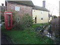
Iwerne Minster: the telephone box
The phone box stands outside what looks as if it may well have once been a watermill, with the stream running through the grounds.
Image: © Chris Downer
Taken: 18 Feb 2013
0.11 miles