IMAGES TAKEN NEAR TO
The Street, BLANDFORD FORUM, DT11 8NU
Introduction
This page details the photographs taken nearby to The Street, DT11 8NU by members of the Geograph project.
The Geograph project started in 2005 with the aim of publishing, organising and preserving representative images for every square kilometre of Great Britain, Ireland and the Isle of Man.

There are currently over 7.5m images from over14,400 individuals and you can help contribute to the project by visiting https://www.geograph.org.uk
Image Map
Images are licensed for reuse under creativecommons.org/licenses/by-sa/2.0
Notes
- Clicking on the map will re-center to the selected point.
- The higher the marker number, the further away the image location is from the centre of the postcode.
Image Listing (71 Images Found)
Images are licensed for reuse under creativecommons.org/licenses/by-sa/2.0
Image
Details
Distance
1
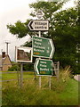
Sutton Waldron: direction signs on the A350
This signpost retains the finial from its predecessor finger-post, giving location and grid reference details.
Manor Farm is reflected rather unevenly in the mirror.
For a close-up of the signpost finial, see Image
Image: © Chris Downer
Taken: 18 Jul 2009
0.04 miles
2

Sutton Waldron: signpost detail
A close-up of the finial from the original finger-post, giving location and grid reference details, which has been retained and affixed to standard modern signage. See Image for the signpost as it looks now.
Image: © Chris Downer
Taken: 13 Mar 2010
0.04 miles
3
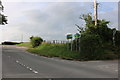
The A350, Sutton Waldron
The two signs replaced ones with more places and mileages on them in the last couple of years.
Image: © David Howard
Taken: 20 Jun 2020
0.05 miles
4
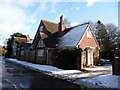
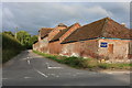
Sutton Waldron: The Old School House
A house with a self-explanatory name.
Image: © Chris Downer
Taken: 7 Feb 2009
0.06 miles
5
Sutton Waldron: postbox № DT11 145
The postbox is emptied at 10am on weekdays and at 7am on Saturdays. The telephone box can be seen a short distance farther on, behind the hedge.
Image: © Chris Downer
Taken: 7 Feb 2009
0.08 miles
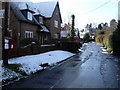
7
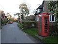
Sutton Waldron: the telephone box
The box stands on the southern side of the main street through the village.
Image: © Chris Downer
Taken: 18 Feb 2013
0.10 miles
8
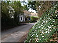
Sutton Waldron: snowdrops and Snowdrop Cottage
A pleasant display of snowdrops on the bank by the village lane, which give the cottage in the background its name.
Image: © Chris Downer
Taken: 13 Mar 2010
0.19 miles
9
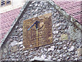
Sundial at St Bartholomews Church
The sundial is above the church door.
Image: © Maigheach-gheal
Taken: 23 Mar 2007
0.22 miles
10
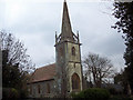
The Church of St Bartholomew, Sutton Waldron
The name Sutton Waldron is broken down as Sutton - South Tun - indicates that in Saxon times it was south of some well known centre which was probably Shaftesbury. Waldron is derived from the name Waleran a huntsman who was given the estate by William the Conqueror.
The Church of St Bartholomew is Victorian which replaced an earlier Saxon church, and it was built entirely at the expense of the incumbent, Canon (later Archdeacon) Huxtable and consecrated in 1847.
Image: © Maigheach-gheal
Taken: 23 Mar 2007
0.22 miles