IMAGES TAKEN NEAR TO
DT11 8FQ
Introduction
This page details the photographs taken nearby to DT11 8FQ by members of the Geograph project.
The Geograph project started in 2005 with the aim of publishing, organising and preserving representative images for every square kilometre of Great Britain, Ireland and the Isle of Man.

There are currently over 7.5m images from over14,400 individuals and you can help contribute to the project by visiting https://www.geograph.org.uk
Image Map
Images are licensed for reuse under creativecommons.org/licenses/by-sa/2.0
Notes
- Clicking on the map will re-center to the selected point.
- The higher the marker number, the further away the image location is from the centre of the postcode.
Image Listing (10 Images Found)
Images are licensed for reuse under creativecommons.org/licenses/by-sa/2.0
Image
Details
Distance
1
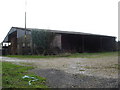
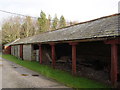
Tarrant Gunville, Drove Barn
Farm on the road to Everley Hill. Perhaps the barn referred to is that to the left, or perhaps that in the distance. Both are built in the vernacular style of bands of brick and flint.
Image: © Mike Faherty
Taken: 21 Jan 2016
0.02 miles
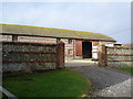
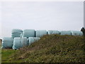
5
Tarrant Gunville, farmyard
At Drove Barn; see also Image
Image: © Mike Faherty
Taken: 21 Jan 2016
0.05 miles
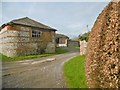
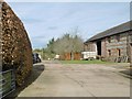
7
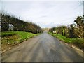
Tarrant Gunville, farm entrance road
To Harbin's Park Farm, part of the Manor Farms group.
Image: © Mike Faherty
Taken: 21 Jan 2016
0.18 miles
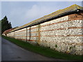
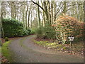
8
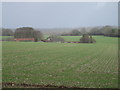
Farmland opposite Westbury Farm
That should be Harbin's Park Farm in the dip.
Image: © Toby
Taken: 30 Dec 2006
0.20 miles