IMAGES TAKEN NEAR TO
Ramsbury Close, BLANDFORD FORUM, DT11 7UF
Introduction
This page details the photographs taken nearby to Ramsbury Close, DT11 7UF by members of the Geograph project.
The Geograph project started in 2005 with the aim of publishing, organising and preserving representative images for every square kilometre of Great Britain, Ireland and the Isle of Man.

There are currently over 7.5m images from over14,400 individuals and you can help contribute to the project by visiting https://www.geograph.org.uk
Image Map (Loading...)


Getting Data...Please wait
Leaflet Map data © OpenStreetMap
Images are licensed for reuse under creativecommons.org/licenses/by-sa/2.0
Notes
- Clicking on the map will re-center to the selected point.
- The higher the marker number, the further away the image location is from the centre of the postcode.
Image Listing (11 Images Found)
Images are licensed for reuse under creativecommons.org/licenses/by-sa/2.0
Image
Details
Distance
1
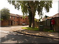
Blandford Forum: postbox № DT11 3, Jubilee Way
This little postbox stands on the corner of Ramsbury Close and serves this modern-ish housing estate on the edge of town. It is emptied at 4pm on weekdays and at 11am on Saturdays.
Image: © Chris Downer
Taken: 27 Jun 2009
0.03 miles
2
The Trailway, Blandford Forum crossing a road
Image: © andrew auger
Taken: 16 Sep 2009
0.06 miles
3
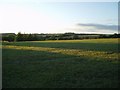
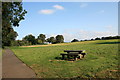
Milldown Common at dusk
A green area for recreation
Image: © Nigel Freeman
Taken: 20 Aug 2006
0.10 miles
5
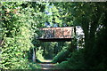
Former railway track & bridge?
I am guessing, but the looks to me as though it was once a railway line and bridge. The bridge carries the road from Milldown common and primary school to the Milldown road on the edge of Blandford Forum.
Image: © andrew auger
Taken: 16 Sep 2009
0.18 miles
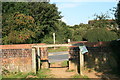
6
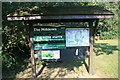
The Milldown information board
The Milldown consists of 40 acres of grassland hedgerow and woodland managed by North Dorset district council. It is part of the Stour Valley project for public enjoyment and wildlife conservation.
Image: © andrew auger
Taken: 16 Sep 2009
0.18 miles
7
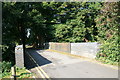
Bridge on the road from Milldown Common to Milldown Road
This is the top of the bridge shown in ST8807 Former railway line and bridge?
Image: © andrew auger
Taken: 16 Sep 2009
0.19 miles
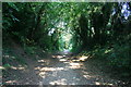
9
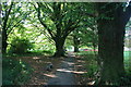
Path through the trees
Heading for Mildown road on the edge of Blandford Forum.
Image: © andrew auger
Taken: 16 Sep 2009
0.19 miles
10
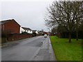
Jubilee Way
Jubilee Way is on the western side of the town and runs from the B3082 right next to the hospital east into the major residential part of the town.
Image: © Nigel Mykura
Taken: 16 Jan 2010
0.21 miles