IMAGES TAKEN NEAR TO
Damory Street, BLANDFORD FORUM, DT11 7FF
Introduction
This page details the photographs taken nearby to Damory Street, DT11 7FF by members of the Geograph project.
The Geograph project started in 2005 with the aim of publishing, organising and preserving representative images for every square kilometre of Great Britain, Ireland and the Isle of Man.

There are currently over 7.5m images from over14,400 individuals and you can help contribute to the project by visiting https://www.geograph.org.uk
Image Map (Loading...)


Getting Data...Please wait
Leaflet Map data © OpenStreetMap
Images are licensed for reuse under creativecommons.org/licenses/by-sa/2.0
Notes
- Clicking on the map will re-center to the selected point.
- The higher the marker number, the further away the image location is from the centre of the postcode.
Image Listing (258 Images Found)
Images are licensed for reuse under creativecommons.org/licenses/by-sa/2.0
Image
Details
Distance
1
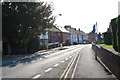
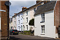
Some aspects of Blandford's architecture: Orchard Street (South)
The view close to the junction with Orchard Place with its mixture of early to mid-C19 housing, and in particular no. 24 Orchard Street.
https://historicengland.org.uk/listing/the-list/list-entry/1108650
Image: © Mike Searle
Taken: 4 May 2014
0.03 miles
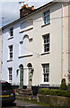
3

Some aspects of Blandford's architecture: 24 Orchard Street
Early to mid-C19. Listed Grade II.
http://www.imagesofengland.org.uk/Details/Default.aspx?id=102216&mode=adv
Image: © Mike Searle
Taken: 4 May 2014
0.03 miles
5
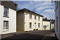
Some aspects of Blandford's architecture: Orchard Street (North)
The view from the junction with Orchard Place of a mixture of early to mid-C19 housing.
https://historicengland.org.uk/listing/the-list/list-entry/1324831
Image: © Mike Searle
Taken: 4 May 2014
0.04 miles
6
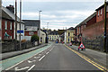
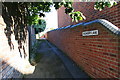
Damory Street, Blandford Forum
Part of the town centre one way system.
Image: © Robin Webster
Taken: 1 Apr 2018
0.04 miles
7
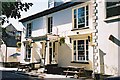
Some aspects of Blandford's architecture: 30 & 32 Orchard Street
Nos. 30 & 32 are central in a group of early to mid-C19 three-storey stucco terraced houses, distinguished by the shared blind Venetian-in-outline window, and sunken elliptical-headed panel above. Listed Grade II.
https://historicengland.org.uk/listing/the-list/list-entry/1324831
Image: © Mike Searle
Taken: 4 May 2014
0.05 miles
8

Blandford Forum: former trackbed of Somerset and Dorset Railway
Image: © Jonathan Hutchins
Taken: Unknown
0.05 miles
9
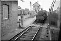
Blandford Forum station & signal box
Seen from the 1.10pm from Bournemouth West, BR Standard 3 2-6-2T 82008 (built Swindon 6/52, withdrawn 2/64) is standing rather unexpectedly on the 'wrong road'. It may be that it has arrived on a terminating local train & has been shunted out of the way of my Bath-bound train. The scene is dominated by the tall signal box on the down platform. Blandford marked the end of the 8 mile double track section from Corfe Mullen. My train will shortly take the 16 mile single track section to Templecombe. The cast iron apparatus by the corner of the goods shed is the Whitaker tablet exchange apparatus used on the S&DJR, here to collect the tablet from southbound trains at the end of the single track section.
Blandford closed to passengers on Monday 7th March 1966 together with the rest of the Somerset & Dorset. However freight traffic continued until 1969.
Image: © Martin Tester
Taken: 14 Aug 1963
0.05 miles