IMAGES TAKEN NEAR TO
Ring Street, STURMINSTER NEWTON, DT10 2QR
Introduction
This page details the photographs taken nearby to Ring Street, DT10 2QR by members of the Geograph project.
The Geograph project started in 2005 with the aim of publishing, organising and preserving representative images for every square kilometre of Great Britain, Ireland and the Isle of Man.

There are currently over 7.5m images from over14,400 individuals and you can help contribute to the project by visiting https://www.geograph.org.uk
Image Map
Images are licensed for reuse under creativecommons.org/licenses/by-sa/2.0
Notes
- Clicking on the map will re-center to the selected point.
- The higher the marker number, the further away the image location is from the centre of the postcode.
Image Listing (106 Images Found)
Images are licensed for reuse under creativecommons.org/licenses/by-sa/2.0
Image
Details
Distance
1
A little chippy
Small but homely fish and chip shop in the heart of Stalbridge, still in coronation colour.
Image: © Neil Owen
Taken: 7 Jun 2023
0.00 miles
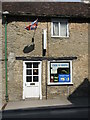
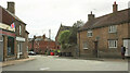
2
Stalbridge: post office and postbox № DT10 110
The post office is at the southern end of the High Street, which becomes Ring Street to the left. Barrow Hill is the side turning. The large, Elizabeth II-reign postbox is emptied finally at 4:40pm on weekdays and at 11:15am on Saturdays.
Image: © Chris Downer
Taken: 23 May 2009
0.01 miles
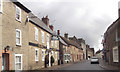
3
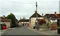
Station Road, Stalbridge
Looking the other way from Image], to where the street meets the High Street, the A357. The Pump House https://historicengland.org.uk/listing/the-list/list-entry/1304441?section=official-list-entry can be glimpsed behind the telegraph pole. The Post Office is also listed https://historicengland.org.uk/listing/the-list/list-entry/1324455?section=official-list-entry .
Image: © Derek Harper
Taken: 26 May 2022
0.02 miles
4
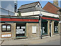
The commercial history goes on
The shop at the corner of Station Road has changed again. It was in its past a pet store, pet charity shop, bookshop and finally a vintage tool and gallery! These are the many change of owners and it looks like it will have another. The village noticeboard remains a fixture though.
Image: © Neil Owen
Taken: 7 Jun 2023
0.02 miles
5
Station Road, Stalbridge
Seen across the junction with the A357 High Street. On the right are numbers 1 and 2 https://historicengland.org.uk/listing/the-list/list-entry/1324459?section=official-list-entry . With its gable end facing the road, the Congregational Church can just be glimpsed behind a bush,
Image: © Derek Harper
Taken: 26 May 2022
0.02 miles
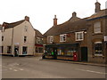
6
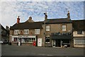
Post Office and Butchers, Stalbridge
Image: © Becky Williamson
Taken: 30 Aug 2018
0.03 miles
7
The dental clinic and the church
A clash of uses and times in Station Road. The dentist's is clearly a conversion of a twentieth century home but the Congregational Church is much older.
Image: © Neil Owen
Taken: 7 Jun 2023
0.03 miles
9
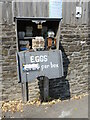
A metal eggbox
Secured with two locks (one on the cabinet, one on the moneybox), this roadside offering fresh eggs at a cost now more in line with the current economic problems.
Image: © Neil Owen
Taken: 7 Jun 2023
0.03 miles
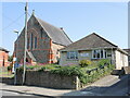
10
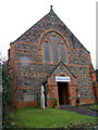
Congregational Chapel, Stalbridge
There is an Ordnance Survey bench mark on the west angle of the building.
Image: © Maigheach-gheal
Taken: 4 Jan 2011
0.04 miles