IMAGES TAKEN NEAR TO
Wessex Road, STURMINSTER NEWTON, DT10 2PF
Introduction
This page details the photographs taken nearby to Wessex Road, DT10 2PF by members of the Geograph project.
The Geograph project started in 2005 with the aim of publishing, organising and preserving representative images for every square kilometre of Great Britain, Ireland and the Isle of Man.

There are currently over 7.5m images from over14,400 individuals and you can help contribute to the project by visiting https://www.geograph.org.uk
Image Map
Images are licensed for reuse under creativecommons.org/licenses/by-sa/2.0
Notes
- Clicking on the map will re-center to the selected point.
- The higher the marker number, the further away the image location is from the centre of the postcode.
Image Listing (33 Images Found)
Images are licensed for reuse under creativecommons.org/licenses/by-sa/2.0
Image
Details
Distance
1
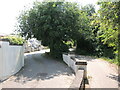
A double route
There is a roadway, servicing the rear of the houses, that matches a footpath off Jarvis Way. Perhaps there was a significant boundary in the past, described with the hedgeline, but it seems extravagant to have two tracks doing the same job.
Image: © Neil Owen
Taken: 7 Jun 2023
0.01 miles
2
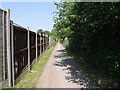
Straight to Jarvis Way
A footpath runs almost Romanesque in style from the road to the playing fields.
Image: © Neil Owen
Taken: 7 Jun 2023
0.01 miles
3
Stalbridge: Bridleway adjoining Jarvis Way
Image: © Mr Eugene Birchall
Taken: 6 Nov 2001
0.07 miles
4
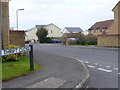
Springfields
Spring fields is a short residential road on a modern housing estate on the south east edge of Stalbridge. it has several small cul-de-sacs off it such as this one Thrift Close.
Image: © Nigel Mykura
Taken: 29 Mar 2013
0.09 miles
5
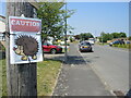
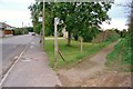
Caution on Jarvis Way
Stalbridge is acutely concerned about its hedgehog welfare. There are several such signs dotted about the village.
Image: © Neil Owen
Taken: 7 Jun 2023
0.11 miles
6
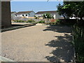
A gravel court outside the hall
A boules court is another offering at Stalbridge Hall.
Image: © Neil Owen
Taken: 7 Jun 2023
0.15 miles
7
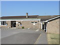
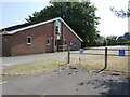
Stalbridge Hall
The village hall is set off Ring Street. Originally the main hall was built in 1974 with the Community Hall added in 1995.
Image: © Neil Owen
Taken: 7 Jun 2023
0.17 miles
8
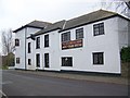
The Stalbridge Arms, Stalbridge
Early 19th century, Grade II listed public house.
Image: © Maigheach-gheal
Taken: 24 Feb 2008
0.17 miles
9
Stalbridge scout hall
North Dorset Scouts are located beside the village hall and the youth centre.
Image: © Neil Owen
Taken: 7 Jun 2023
0.17 miles
10

Sign for the Stalbridge Arms, Stalbridge
Sign for Image]
Image: © Maigheach-gheal
Taken: 24 Feb 2008
0.18 miles