IMAGES TAKEN NEAR TO
Ring Street, STURMINSTER NEWTON, DT10 2LZ
Introduction
This page details the photographs taken nearby to Ring Street, DT10 2LZ by members of the Geograph project.
The Geograph project started in 2005 with the aim of publishing, organising and preserving representative images for every square kilometre of Great Britain, Ireland and the Isle of Man.

There are currently over 7.5m images from over14,400 individuals and you can help contribute to the project by visiting https://www.geograph.org.uk
Image Map
Images are licensed for reuse under creativecommons.org/licenses/by-sa/2.0
Notes
- Clicking on the map will re-center to the selected point.
- The higher the marker number, the further away the image location is from the centre of the postcode.
Image Listing (87 Images Found)
Images are licensed for reuse under creativecommons.org/licenses/by-sa/2.0
Image
Details
Distance
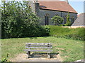
1
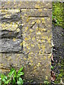
Bench Mark, Methodist Chapel
The bench mark is to be found on the south west face of the chapel. For a wider view of the chapel Image and for further information on the bench mark and others in the area http://www.bench-marks.org.uk/bm36444
Image: © Maigheach-gheal
Taken: 4 Jan 2011
0.01 miles
2
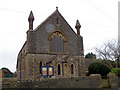
Methodist Chapel, Stalbridge
The chapel is on Ring Street. There is an Ordnance Survey bench mark on the south west face.
Image: © Maigheach-gheal
Taken: 4 Jan 2011
0.01 miles
3
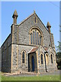
Former Methodist church on Stalbridge High Street
Now a private residence from about 2013, the old building has a benchmark on it - see Image
Image: © Neil Owen
Taken: 7 Jun 2023
0.01 miles
4
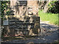
Benchmark on the old Methodist church
A cutmark, as listed in the Benchmark Database: https://www.bench-marks.org.uk/bm36444 , on the former church in Stalbridge. See Image] for a location view.
Image: © Neil Owen
Taken: 7 Jun 2023
0.01 miles
5
A seat on Stalbridge Close
A small corner plot (perhaps the site of a former house?) on the junction with the A357 main road offers a seat.
Image: © Neil Owen
Taken: 7 Jun 2023
0.02 miles

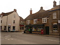
7
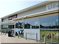
The independent supermarket
Dike and Son has a large presence in a new suite of shops here in the middle of Stalbridge. The company is an independent supermarket, café and function caterer in North Dorset, family-run since its founding as a grocery supplier in 1851.
Image: © Neil Owen
Taken: 7 Jun 2023
0.04 miles
8
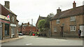
Station Road, Stalbridge
Seen across the junction with the A357 High Street. On the right are numbers 1 and 2 https://historicengland.org.uk/listing/the-list/list-entry/1324459?section=official-list-entry . With its gable end facing the road, the Congregational Church can just be glimpsed behind a bush,
Image: © Derek Harper
Taken: 26 May 2022
0.04 miles
9
A little chippy
Small but homely fish and chip shop in the heart of Stalbridge, still in coronation colour.
Image: © Neil Owen
Taken: 7 Jun 2023
0.05 miles
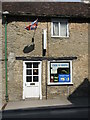
10
Stalbridge: post office and postbox № DT10 110
The post office is at the southern end of the High Street, which becomes Ring Street to the left. Barrow Hill is the side turning. The large, Elizabeth II-reign postbox is emptied finally at 4:40pm on weekdays and at 11:15am on Saturdays.
Image: © Chris Downer
Taken: 23 May 2009
0.05 miles