IMAGES TAKEN NEAR TO
Westminster Buildings, STURMINSTER NEWTON, DT10 1HZ
Introduction
This page details the photographs taken nearby to Westminster Buildings, DT10 1HZ by members of the Geograph project.
The Geograph project started in 2005 with the aim of publishing, organising and preserving representative images for every square kilometre of Great Britain, Ireland and the Isle of Man.

There are currently over 7.5m images from over14,400 individuals and you can help contribute to the project by visiting https://www.geograph.org.uk
Image Map (Loading...)


Getting Data...Please wait
Leaflet Map data © OpenStreetMap
Images are licensed for reuse under creativecommons.org/licenses/by-sa/2.0
Notes
- Clicking on the map will re-center to the selected point.
- The higher the marker number, the further away the image location is from the centre of the postcode.
Image Listing (48 Images Found)
Images are licensed for reuse under creativecommons.org/licenses/by-sa/2.0
Image
Details
Distance
1
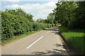
Shave Lane
The Hardy Way follows this lane through Todber. View from the same spot as Image
Image: © Derek Harper
Taken: 26 May 2016
0.04 miles
2
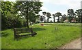
Hardy Way at the B3092
A seat beside Shave Lane by its junction with the B road, which seems to be closed south of here, if the sign is to be believed. The Hardy Way crosses the B road here.
Image: © Derek Harper
Taken: 26 May 2016
0.07 miles
3
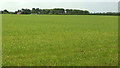
Field near Todber #2
Looking to the right from the same spot as Image], with a little overlap. The distant houses are on Shave Lane.
Image: © Derek Harper
Taken: 26 May 2016
0.08 miles
5
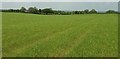
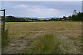
Field near Todber #3
Looking to the right from the same spot as Image], with a little overlap. This is the direction of footpath N73 5, towards Northfield House, on the left of the image on the side of a shallow valley. The house is listed and described at https://www.historicengland.org.uk/listing/the-list/list-entry/1324536 .
Image: © Derek Harper
Taken: 26 May 2016
0.11 miles
6
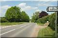
B3092 at Todber
At the junction with Great Down Lane (left). The road sign is for St Mary's Catholic Primary School.
Image: © Derek Harper
Taken: 26 May 2016
0.12 miles
7
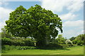
Field boundary near Northfield House
I'm searching for the exit from the field for footpath N73 5, but it emerges later that I've already missed it, and it can't have been where the map shows it. However, I decide to head for the obvious fence near the oak tree and end up in someone's garden.
Image: © Derek Harper
Taken: 26 May 2016
0.13 miles
8
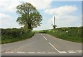
Great Down Lane
From the junction with the B3092 where Image] was taken. The lane leads to Marnhull.
Image: © Derek Harper
Taken: 26 May 2016
0.13 miles
9
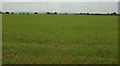
Field near Todber #1
Footpath N73 5 crosses a large field on its way to meet the B3092. This view is towards Todber.
Image: © Derek Harper
Taken: 26 May 2016
0.14 miles
10
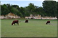
Cows and limestone
There are active quarries in the neighbourhood and it looks as if this field was previously quarried as the side away from the road is formed by a low limestone cliff.
Image: © David Martin
Taken: 11 Jul 2015
0.15 miles