IMAGES TAKEN NEAR TO
Church Lane, DONCASTER, DN9 3BL
Introduction
This page details the photographs taken nearby to Church Lane, DN9 3BL by members of the Geograph project.
The Geograph project started in 2005 with the aim of publishing, organising and preserving representative images for every square kilometre of Great Britain, Ireland and the Isle of Man.

There are currently over 7.5m images from over14,400 individuals and you can help contribute to the project by visiting https://www.geograph.org.uk
Image Map
Images are licensed for reuse under creativecommons.org/licenses/by-sa/2.0
Notes
- Clicking on the map will re-center to the selected point.
- The higher the marker number, the further away the image location is from the centre of the postcode.
Image Listing (31 Images Found)
Images are licensed for reuse under creativecommons.org/licenses/by-sa/2.0
Image
Details
Distance
1
Old Boundary Marker on the A614 Doncaster Road, Finningley
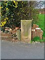
County Boundary Marker against a brick garden wall on the northwest side of the junction of the A614 Doncaster Road and Honeysuckle Court. Words are WEST RIDING C C on the left face, NOTTS C C on the right face, both vertically and COUNTY on its top. On the boundary of Blaxton and Finningley parishes, Finningley was in Nottinghamshire until 1974 and thereafter both were in South Yorkshire and Doncaster.
Milestone Society National ID: YW_BLAFIN01cb
Image: © R Heywood
Taken: Unknown
0.05 miles
2
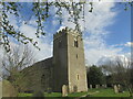
Holy Trinity and St Oswald's Church
Village church in Finningley.
Image: © steven ruffles
Taken: 26 Mar 2021
0.13 miles
3
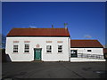
The Village Hall, Finningley
This building has a varied history. It began life as a barn, was converted to a school in 1839 and is now the Village Hall. http://www.britishlistedbuildings.co.uk/en-334764-the-village-hall-finningley-
Image: © Jonathan Thacker
Taken: 10 Jan 2015
0.13 miles
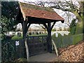
4
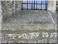
Ordnance Survey 1GL Bolt
This OS Bolt can be found on the north face of Holy Trinity Church. It marks a point 8.824m above mean sea level.
Image: © Adrian Dust
Taken: 24 May 2016
0.13 miles
5
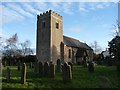
Church of Holy Trinity and St Oswald
Grade I listed parish church dating from the 11th century
Image: © Graham Hogg
Taken: 10 Jan 2017
0.14 miles
6
Holy Trinity and St Oswald's Church, Finningley
Image: © Neil Theasby
Taken: 6 Sep 2016
0.14 miles
7
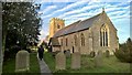
Holy Trinity & St Oswald's parish church, Finningley
Image: © Chris Morgan
Taken: 10 Jan 2017
0.14 miles
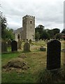
8
Entrance to Finningley New Cemetery
The new cemetery houses graves from the second half of the 20th century to the present date.
Image: © Graham Hogg
Taken: 10 Jan 2017
0.14 miles
9
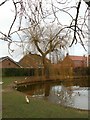
Winter tree by the duck pond
In Fillingley village
Image: © Graham Hogg
Taken: 10 Jan 2017
0.14 miles
10
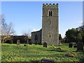
Holy Trinity church, Finningley
Norman west tower http://www.britishlistedbuildings.co.uk/en-334765-church-of-holy-trinity-and-st-oswald-fin
Image: © Jonathan Thacker
Taken: 10 Jan 2015
0.14 miles