IMAGES TAKEN NEAR TO
Akeferry Road, DONCASTER, DN9 2NG
Introduction
This page details the photographs taken nearby to Akeferry Road, DN9 2NG by members of the Geograph project.
The Geograph project started in 2005 with the aim of publishing, organising and preserving representative images for every square kilometre of Great Britain, Ireland and the Isle of Man.

There are currently over 7.5m images from over14,400 individuals and you can help contribute to the project by visiting https://www.geograph.org.uk
Image Map
Images are licensed for reuse under creativecommons.org/licenses/by-sa/2.0
Notes
- Clicking on the map will re-center to the selected point.
- The higher the marker number, the further away the image location is from the centre of the postcode.
Image Listing (29 Images Found)
Images are licensed for reuse under creativecommons.org/licenses/by-sa/2.0
Image
Details
Distance
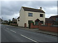
1
Akeferry Road, Graizelound
Approaching the A161 - heading east.
Image: © JThomas
Taken: 28 Feb 2015
0.04 miles
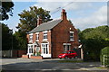
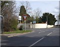
3
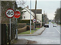
The perils of absolute rules for sign installation
Approaching this junction in a 30 mph zone you are permitted to accelerate to 40 mph before having to stop within 5 metres. After starting off you are again permitted to reach 40 mph within a few more metres before having to brake for the 30mph restriction beyond. All this simply because the intersecting road has a 40 mph limit. Crossroads at Graizelound
Image: © Alan Murray-Rust
Taken: 13 Mar 2011
0.05 miles
4
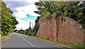
Old bridge 28, Akeferry Road, Graizelound
This old railway bridge abutment is not matched on the other side of the road.
Image: © Chris Morgan
Taken: 29 Sep 2015
0.05 miles
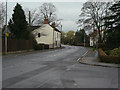
5
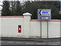
Postbox at Station Road, Craizelound ref: DN9 104
At Graizelound crossroads. For some comments on the spelling of the placename see the gridsquare discussion.
Image: © Alan Murray-Rust
Taken: 13 Mar 2011
0.06 miles
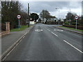
7
A161 at Graizelound
Looking south at the crossroads towards Misterton.
Image: © Alan Murray-Rust
Taken: 13 Mar 2011
0.07 miles