IMAGES TAKEN NEAR TO
Haxey Lane, DONCASTER, DN9 2NE
Introduction
This page details the photographs taken nearby to Haxey Lane, DN9 2NE by members of the Geograph project.
The Geograph project started in 2005 with the aim of publishing, organising and preserving representative images for every square kilometre of Great Britain, Ireland and the Isle of Man.

There are currently over 7.5m images from over14,400 individuals and you can help contribute to the project by visiting https://www.geograph.org.uk
Image Map
Images are licensed for reuse under creativecommons.org/licenses/by-sa/2.0
Notes
- Clicking on the map will re-center to the selected point.
- The higher the marker number, the further away the image location is from the centre of the postcode.
Image Listing (40 Images Found)
Images are licensed for reuse under creativecommons.org/licenses/by-sa/2.0
Image
Details
Distance
1

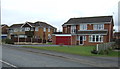
Haxey Cricket Ground Haxey Isle of Axholme North Lincolnshire
Haxey Cricket Ground Haxey Lane viewed from Graizelound Fields Rd
Image: © Bob Pearce
Taken: 26 Aug 2017
0.09 miles
3
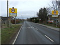
Entering Haxey
Heading north on Haxey Lane (A161).
Image: © JThomas
Taken: 28 Feb 2015
0.15 miles
4
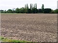
Trees at the edge of a bare field
One of the Graizelound Fields, west of the eponymous road.
Image: © Christine Johnstone
Taken: 8 Oct 2011
0.16 miles
5
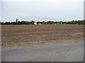
Bare field, west of Graizelound Fields Road
With Field House at the edge of Haxey in the distance.
Image: © Christine Johnstone
Taken: 8 Oct 2011
0.17 miles
6
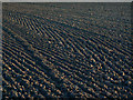
Patterns in the soil
I am intrigued to know what machine has caused these remarkable herringbone patterns. You might even think the farmer had gone out of his way to make it look pretty.
Image: © Alan Murray-Rust
Taken: 13 Mar 2011
0.19 miles
7
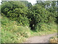
Path beneath the railway
The railway has long gone but the embankment remains at this point.
Image: © Jonathan Thacker
Taken: 1 Aug 2010
0.19 miles
8

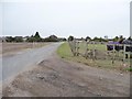
Graizelound Fields Road
Towards Haxey on Graizelound Fields Road
Image: © Richard Croft
Taken: 28 Mar 2012
0.19 miles
9
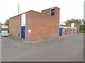
Haxey Telephone Exchange
Situated in Low Street, this TE dates from the mid 1970s replacing the smaller TE in front of it https://www.geograph.org.uk/photo/6400843 refers. It has the code SLHX and provides telephone and broadband services to 1,869 residential and 54 non-residential premises in Haxey and the surrounding area including East Lound, Graizelound and Westwoodside. Two white BT warning notices have been fixed on this TE whilst a pale green generator is to the left of the photo. The numbering range of this TE is (01427) 75xxxx, the (01427) referring to the Gainsborough group of twelve TEs, and its postcode is DN9 2LA.
Image: © David Hillas
Taken: 18 Jul 2019
0.20 miles
10
Graizelound Fields Road, heading into Haxey
The reason for the atypical fencing is clear.
Image: © Christine Johnstone
Taken: 8 Oct 2011
0.20 miles