IMAGES TAKEN NEAR TO
Low Hall Road, DONCASTER, DN9 2LU
Introduction
This page details the photographs taken nearby to Low Hall Road, DN9 2LU by members of the Geograph project.
The Geograph project started in 2005 with the aim of publishing, organising and preserving representative images for every square kilometre of Great Britain, Ireland and the Isle of Man.

There are currently over 7.5m images from over14,400 individuals and you can help contribute to the project by visiting https://www.geograph.org.uk
Image Map
Images are licensed for reuse under creativecommons.org/licenses/by-sa/2.0
Notes
- Clicking on the map will re-center to the selected point.
- The higher the marker number, the further away the image location is from the centre of the postcode.
Image Listing (18 Images Found)
Images are licensed for reuse under creativecommons.org/licenses/by-sa/2.0
Image
Details
Distance
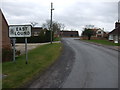
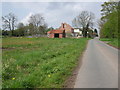
3
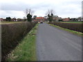
East Lound
A small village with one through route about a kilometre east of Haxey.
Image: © David Squire
Taken: 10 May 2006
0.07 miles
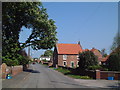
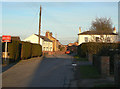
6
Carr Lane, East Lound
Looking north on the outskirts of the village.
Image: © David Squire
Taken: 10 May 2006
0.11 miles
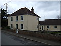
7
Brackenhill Road, East Lound
The main street through the village in the rays of the setting sun.
Image: © Alan Murray-Rust
Taken: 13 Mar 2011
0.15 miles
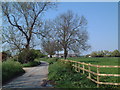
8
Minor road into East Lound
Heading south west.
Image: © JThomas
Taken: 28 Feb 2015
0.16 miles
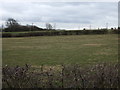
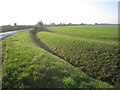
9
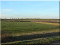
Landscape near East Lound
Flat fenland field rise gently to the higher land of the Isle of Axholme.
Image: © Alan Murray-Rust
Taken: 13 Mar 2011
0.18 miles