IMAGES TAKEN NEAR TO
Haxey Carr, DONCASTER, DN9 2JR
Introduction
This page details the photographs taken nearby to DN9 2JR by members of the Geograph project.
The Geograph project started in 2005 with the aim of publishing, organising and preserving representative images for every square kilometre of Great Britain, Ireland and the Isle of Man.

There are currently over 7.5m images from over14,400 individuals and you can help contribute to the project by visiting https://www.geograph.org.uk
Image Map
Images are licensed for reuse under creativecommons.org/licenses/by-sa/2.0
Notes
- Clicking on the map will re-center to the selected point.
- The higher the marker number, the further away the image location is from the centre of the postcode.
Image Listing (3 Images Found)
Images are licensed for reuse under creativecommons.org/licenses/by-sa/2.0
Image
Details
Distance
1
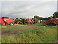
Graveyard for farm machinery
Some of these machines look as if they might work again, but many have vegetation growing out of them.
Image: © Jonathan Thacker
Taken: 29 Jul 2010
0.02 miles