IMAGES TAKEN NEAR TO
Lowcroft Avenue, DONCASTER, DN9 2HG
Introduction
This page details the photographs taken nearby to Lowcroft Avenue, DN9 2HG by members of the Geograph project.
The Geograph project started in 2005 with the aim of publishing, organising and preserving representative images for every square kilometre of Great Britain, Ireland and the Isle of Man.

There are currently over 7.5m images from over14,400 individuals and you can help contribute to the project by visiting https://www.geograph.org.uk
Image Map
Images are licensed for reuse under creativecommons.org/licenses/by-sa/2.0
Notes
- Clicking on the map will re-center to the selected point.
- The higher the marker number, the further away the image location is from the centre of the postcode.
Image Listing (51 Images Found)
Images are licensed for reuse under creativecommons.org/licenses/by-sa/2.0
Image
Details
Distance
1

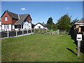
Haxey Parish Nature Trail
The Trail runs along the route of a former railway line (closed in 1956), from Haxey to Epworth.
Image: © Tim Heaton
Taken: 23 Oct 2015
0.03 miles
2

The former route of the Axholme Joint Railway in Haxey
Construction of the Axholme Joint Railway between Haxey and Goole started in 1899 and opened in August 1903 but the part to Haxey was not opened until 2nd January 1905. For several years, there were two passenger trains and one goods train on weekdays, but extra trains were run on Saturdays and on some Market days. Local farmers used to cart their produce to Haxey Town and Haxey Junction stations and load it into trucks. The goods train brought mail, coal and all the other things that the villagers needed as there was no other way of transporting them. The line began to decline after 1924 with the introduction of bus services in the Isle of Axholme and lorries coming onto the roads to transport goods.
Passenger services ceased on 15th July 1933 and the section from Haxey Junction to Epworth was finally closed completely on 1st February 1956. The land is now managed by North Lincolnshire Council as a footpath and linear nature trail, running from the High Street in Haxey to Epworth. Much of it is in a wooded cutting until it reaches Cliff Hill where it is on an embankment. This is the view further south from High Street.
A much fuller account can be seen at http://www.axholme.info/railway.html and at https://en.wikipedia.org/wiki/Axholme_Joint_Railway More information can be found at https://www.haxeywalkers.co.uk/pictures-of-the-isle-of-axholme-light-railway-near-haxey/
Image: © Marathon
Taken: 8 Sep 2019
0.03 miles
3
The former route of the Axholme Joint Railway in Haxey
Construction of the Axholme Joint Railway between Haxey and Goole started in 1899 and opened in August 1903 but the part to Haxey was not opened until 2nd January 1905. For several years, there were two passenger trains and one goods train on weekdays, but extra trains were run on Saturdays and on some Market days. Local farmers used to cart their produce to Haxey Town and Haxey Junction stations and load it into trucks. The goods train brought mail, coal and all the other things that the villagers needed as there was no other way of transporting them. The line began to decline after 1924 with the introduction of bus services in the Isle of Axholme and lorries coming onto the roads to transport goods.
Passenger services ceased on 15th July 1933 and the section from Haxey Junction to Epworth was finally closed completely on 1st February 1956. The land is now managed by North Lincolnshire Council as a footpath and linear nature trail, running from the High Street in Haxey to Epworth. Much of it is in a wooded cutting until it reaches Cliff Hill where it is on an embankment. This is the view further south from High Street.
A much fuller account can be seen at http://www.axholme.info/railway.html and at https://en.wikipedia.org/wiki/Axholme_Joint_Railway More information can be found at https://www.haxeywalkers.co.uk/pictures-of-the-isle-of-axholme-light-railway-near-haxey/
Image: © Marathon
Taken: 8 Sep 2019
0.04 miles
4
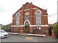
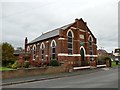
Haxey Methodist Church, Lincs
Situated in Low Street DN9 2LA, this Methodist Church dates from 1909, and is one of several churches in the Epworth and Scunthorpe Methodist Circuit. Services are held here most Sundays at 10.45am with activities taking place during the week. Above the entrance is a green oval notice which has the following wording:
The Millennium is
CHRIST'S 2000th BIRTHDAY
Worship Him here - now
Image: © David Hillas
Taken: 18 Jul 2019
0.05 miles
5
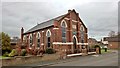
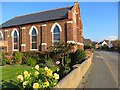
Haxey Memorial Primitive Methodist Chapel
This area is the birthplace of Methodism no surprise that there should be an active chapel here. More about the church history at; http://www.myprimitivemethodists.org.uk/page/haxey_memorial_primitive_methodist_chapel_lincolnshire
Image: © Chris Morgan
Taken: 21 Nov 2017
0.05 miles
6
Haxey Memorial Primitive Methodist Chapel
Date stone of 1909. http://www.myprimitivemethodists.org.uk/page_id__1906.aspx
Image: © Tim Heaton
Taken: 24 Jul 2015
0.05 miles
7
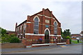
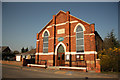
Haxey Methodist Church
A stone dates the building to 1909
Image: © Graham Hogg
Taken: 21 Nov 2017
0.05 miles
8
Haxey High Street
With the Methodist Chapel on the left
Image: © Paul Harrop
Taken: 25 Oct 2016
0.06 miles
9
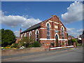
Haxey Methodist Church
Methodist church on High Street with a datestone of 1909
Image: © Richard Croft
Taken: 28 Mar 2012
0.06 miles
10
Haxey Methodist Church
Haxey Methodist Church dates from 1909 as confirmed by the plaque on the wall above the door.
Image: © Marathon
Taken: 8 Sep 2019
0.06 miles