IMAGES TAKEN NEAR TO
Greenholme Bank, DONCASTER, DN9 2FE
Introduction
This page details the photographs taken nearby to Greenholme Bank, DN9 2FE by members of the Geograph project.
The Geograph project started in 2005 with the aim of publishing, organising and preserving representative images for every square kilometre of Great Britain, Ireland and the Isle of Man.

There are currently over 7.5m images from over14,400 individuals and you can help contribute to the project by visiting https://www.geograph.org.uk
Image Map
Images are licensed for reuse under creativecommons.org/licenses/by-sa/2.0
Notes
- Clicking on the map will re-center to the selected point.
- The higher the marker number, the further away the image location is from the centre of the postcode.
Image Listing (15 Images Found)
Images are licensed for reuse under creativecommons.org/licenses/by-sa/2.0
Image
Details
Distance
1
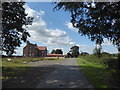
Star Carr
My grandmother was born at Star Carr in 1896. In those days it was just an isolated farmhouse in a very remote setting. I visited here in 2007 and then all that could be seen was the floor of the old farmhouse and it was freely accessible. Now 12 years later there is no access and the footpath has been diverted around the perimeter of the property - see https://www.geograph.org.uk/photo/6260702 Looking at old maps and the aerial photo this large house has been built a little way to the east of the old Star Carr at some time in the last 12 years, but the site of the old farmhouse is still there.
Image: © Marathon
Taken: 8 Sep 2019
0.01 miles
2
Star Carr
My grandmother was born at Star Carr in 1896. In those days it was just an isolated farmhouse in a very remote setting. I visited here in 2007 and then all that could be seen was the floor of the old farmhouse and it was freely accessible. Now 12 years later there is no access and the footpath has been diverted around the perimeter of the property - see https://www.geograph.org.uk/photo/6260702 Looking at old maps and the aerial photo this large house has been built a little way to the east of the old Star Carr at some time in the last 12 years, but the site of the old farmhouse is still to be seen down the lane in the distance.
Image: © Marathon
Taken: 8 Sep 2019
0.02 miles
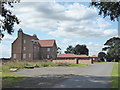
3
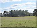
Farmhouse near Westwoodside
Seen from the public bridleway along Greenholme Bank - the apparently huge lawn in the foreground is a field growing grass for turf.
Image: © Paul Harrop
Taken: 25 Oct 2016
0.06 miles
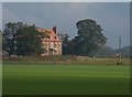
4
View from the diverted footpath at Star Carr
The footpath at Star Carr has been diverted around the grounds of the recently rebuilt Star Carr - see https://www.geograph.org.uk/photo/6260719 and https://www.geograph.org.uk/photo/6260702 This view is from the corner of the diverted path where it leaves Greenholme Bank. The new house of Star Carr is just behind the trees to the left.
Image: © Marathon
Taken: 8 Sep 2019
0.09 miles
5
View from the diverted footpath at Star Carr
The footpath at Star Carr has been diverted around the grounds of the recently rebuilt Star Carr - see https://www.geograph.org.uk/photo/6260719 and https://www.geograph.org.uk/photo/6260702 This view is from the corner of the diverted path where it leaves Greenholme Bank. The new house of Star Carr is just behind the trees to the left.
Image: © Marathon
Taken: 8 Sep 2019
0.09 miles
6
View from the diverted footpath at Star Carr
The footpath at Star Carr has been diverted around the grounds of the recently rebuilt Star Carr - see https://www.geograph.org.uk/photo/6260719 and https://www.geograph.org.uk/photo/6260702 This view is from the corner of the diverted path. The new house of Star Carr is just out of the picture to the left.
Image: © Marathon
Taken: 8 Sep 2019
0.09 miles
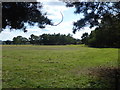
7
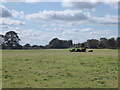
There's money in the turf
Many a lawn to be covered from fields grown like this on flat and sandy soils
Image: © Chris Morgan
Taken: 21 Nov 2017
0.13 miles
8
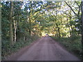
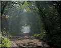
Greenholme Bank
In its 3km length Greenholme Bank provides some contrasting vistas. Here it is a shady avenue.
Image: © Jonathan Thacker
Taken: 29 Jul 2010
0.15 miles
9
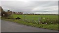
Greenholme Bank near Westwoodside
A long, straight public bridleway leading northwards from the north-western end of Westwoodside
Image: © Paul Harrop
Taken: 25 Oct 2016
0.18 miles
10
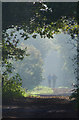
Bridleway near Westwoodside
Greenholme Bank is a wide, straight public bridleway which also forms part of the Peatlands Way, a 50 mile footpath route.
Image: © Paul Harrop
Taken: 25 Oct 2016
0.18 miles