IMAGES TAKEN NEAR TO
Langholme Lane, DONCASTER, DN9 2EX
Introduction
This page details the photographs taken nearby to Langholme Lane, DN9 2EX by members of the Geograph project.
The Geograph project started in 2005 with the aim of publishing, organising and preserving representative images for every square kilometre of Great Britain, Ireland and the Isle of Man.

There are currently over 7.5m images from over14,400 individuals and you can help contribute to the project by visiting https://www.geograph.org.uk
Image Map
Images are licensed for reuse under creativecommons.org/licenses/by-sa/2.0
Notes
- Clicking on the map will re-center to the selected point.
- The higher the marker number, the further away the image location is from the centre of the postcode.
Image Listing (5 Images Found)
Images are licensed for reuse under creativecommons.org/licenses/by-sa/2.0
Image
Details
Distance
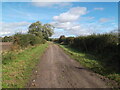
1
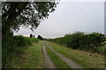
Langholme Lane heading towards Haxey
The water tower on Tower Hill, Haxey, is visible on the horizon
Image: © Tim Heaton
Taken: 24 Jul 2015
0.05 miles
3
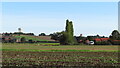
Langholme Farm & view towards Haxey Water Tower & Church
Image: © Colin Park
Taken: 13 Sep 2022
0.09 miles
5
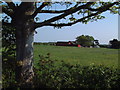
Near Langholme Lane
View across the farmland about half way between Graiselound / Craiselound and Westwoodside.
Image: © David Squire
Taken: 10 May 2006
0.23 miles