IMAGES TAKEN NEAR TO
Westwoodside, DONCASTER, DN9 2EW
Introduction
This page details the photographs taken nearby to DN9 2EW by members of the Geograph project.
The Geograph project started in 2005 with the aim of publishing, organising and preserving representative images for every square kilometre of Great Britain, Ireland and the Isle of Man.

There are currently over 7.5m images from over14,400 individuals and you can help contribute to the project by visiting https://www.geograph.org.uk
Image Map
Images are licensed for reuse under creativecommons.org/licenses/by-sa/2.0
Notes
- Clicking on the map will re-center to the selected point.
- The higher the marker number, the further away the image location is from the centre of the postcode.
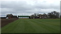
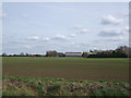
Image Listing (19 Images Found)
Images are licensed for reuse under creativecommons.org/licenses/by-sa/2.0
Image
Details
Distance

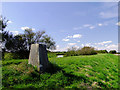
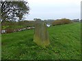
4
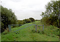
Trig point of Idle Stop
The name Idle Stop comes in part from the River Idle which lies immediately behind the camera position. The pillar is on a flood defence bank known as Participants Bank. South Carr Farm is beside the earthen field.
Image: © Trevor Littlewood
Taken: 12 Mar 2005
0.11 miles
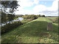
5
Idle Stop Ordnance Survey Trig Pillar
Image: © Siobhan Brennan-Raymond
Taken: 10 Sep 2009
0.11 miles
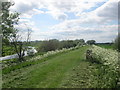
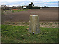
9
Triangulation point on the River Idle flood bank
At a height of 5' above sea level this must be one of the lowest trig points in the UK
Image: © Graham Hogg
Taken: 24 Oct 2019
0.11 miles